IMAGES TAKEN NEAR TO
Brookes Hill Industrial Estate, Salisbury Road, SOUTHAMPTON, SO40 2QT
Introduction
This page details the photographs taken nearby to Brookes Hill Industrial Estate, Salisbury Road, SO40 2QT by members of the Geograph project.
The Geograph project started in 2005 with the aim of publishing, organising and preserving representative images for every square kilometre of Great Britain, Ireland and the Isle of Man.

There are currently over 7.5m images from over14,400 individuals and you can help contribute to the project by visiting https://www.geograph.org.uk
Image Map (Loading...)


Getting Data...Please wait
Leaflet Map data © OpenStreetMap
Images are licensed for reuse under creativecommons.org/licenses/by-sa/2.0
Notes
- Clicking on the map will re-center to the selected point.
- The higher the marker number, the further away the image location is from the centre of the postcode.
Image Listing (13 Images Found)
Images are licensed for reuse under creativecommons.org/licenses/by-sa/2.0
Image
Details
Distance
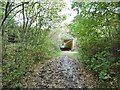
3
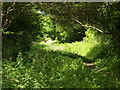
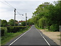
Footpath from Paulett's Lane to Shorn Hill
Footpath from Paulett's Lane towards the A326 underpass.....
watch out for the ill kept dogs, they tend
to attack walkers.
Image: © david coombes
Taken: 18 May 2009
0.16 miles
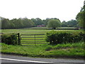
4
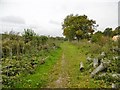
Calmore, bridleway
Between fields, from Pauletts Lane to Loperwood Lane.
Image: © Mike Faherty
Taken: 19 Oct 2015
0.16 miles
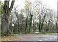

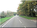
8
Calmore, subway
Taking the bridleway/farm road under A326.
Image: © Mike Faherty
Taken: 19 Oct 2015
0.19 miles