1
South Downs Society Green Travel Walks Week (190)
The High Street in mid September
Image: © Basher Eyre
Taken: 19 Sep 2011
0.02 miles
2
South Downs Society Green Travel Walks Week (192)
This one is open on a Monday, whereas the other one is not!
Image: © Basher Eyre
Taken: 19 Sep 2011
0.02 miles
3
White Horse Inn Droxford
First pub in Droxford Village, when coming along the A32 from Wickham.
Image: © Jim Goldsmith
Taken: 20 Nov 2005
0.03 miles
4
Police Station Lane, Droxford
So named because of
Image . The A32 is in foreground.
Image: © Peter Facey
Taken: 21 Oct 2007
0.03 miles
5
South Downs Society Green Travel Walks Week (191)
Junction of Police Station Lane and High Street
Image: © Basher Eyre
Taken: 19 Sep 2011
0.03 miles
6
South Downs Society Green Travel Walks Week (189)
A unique road name in England!
Image: © Basher Eyre
Taken: 19 Sep 2011
0.03 miles
7
High Street, Droxford
Droxford is built around the busy A32. Turn left beyond the red car to reach the Manor House and church, or turn right into Park Lane.
Image: © Peter Facey
Taken: 21 Oct 2007
0.04 miles
8
Old police station, Droxford
The green plaque on the building reads "County Police Station 1858". It is now Droxford Health & Beauty Club.
Image: © Peter Facey
Taken: 21 Oct 2007
0.06 miles
9
Former Bethel Primitive Methodist Chapel, Droxford
The plaque is dated 1886. It appears now to be owned by a florist.
Image: © Peter Facey
Taken: 21 Oct 2007
0.06 miles
10
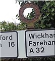
Old Direction Sign - Signpost by the A32, Midlington Road, Droxford
Annulus finial - lost; Hampshire Parish halo by the A32, in parish of Droxford (Winchester District), Midlington Road, at Y-junction. Old annulus bolted to new road sign.
Surveyed
Milestone Society National ID: HA_SU6018
Image: © Milestone Society
Taken: Unknown
0.07 miles


