IMAGES TAKEN NEAR TO
Wheatear Road, SO32 2TX
Introduction
This page details the photographs taken nearby to Wheatear Road, SO32 2TX by members of the Geograph project.
The Geograph project started in 2005 with the aim of publishing, organising and preserving representative images for every square kilometre of Great Britain, Ireland and the Isle of Man.

There are currently over 7.5m images from over14,400 individuals and you can help contribute to the project by visiting https://www.geograph.org.uk
Image Map
Images are licensed for reuse under creativecommons.org/licenses/by-sa/2.0
Notes
- Clicking on the map will re-center to the selected point.
- The higher the marker number, the further away the image location is from the centre of the postcode.
Image Listing (16 Images Found)
Images are licensed for reuse under creativecommons.org/licenses/by-sa/2.0
Image
Details
Distance
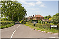
2
Junction of Maddoxford Lane and Crows Nest Lane
Entering Boorley Green from the east.
Image: © Peter Facey
Taken: 24 May 2009
0.05 miles
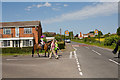
3

Approaching Boorley Green on Maddoxford Lane
Image: © Peter Facey
Taken: 24 May 2009
0.05 miles
4

Valve number 7, Esso Fawley-London multi-fuel pipeline
Oak Ridge Farm beyond.
Image: © Peter Facey
Taken: 24 May 2009
0.09 miles
5
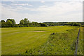
Botley Park Golf Course
Seen from footpath. Photographer is standing on a stile.
Image: © Peter Facey
Taken: 24 May 2009
0.09 miles
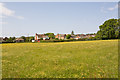
6

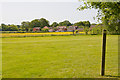
Buttercup meadow at Boorley Green
Between the village and the Botley Park Golf Course.
Image: © Peter Facey
Taken: 24 May 2009
0.12 miles
7
Buttercup meadow at Boorley Green
Seen from footpath as it leaves Botley Park Golf Course.
Image: © Peter Facey
Taken: 24 May 2009
0.14 miles
8
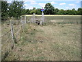
Footpath approaching Boorley Green
Crossing Botley Park Golf Course.
Image: © Peter Facey
Taken: 24 May 2009
0.14 miles
9
Footpath approaching Botley Park Golf Course
Image: © Chris Wimbush
Taken: 9 Aug 2010
0.16 miles
10
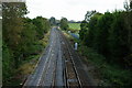
View Towards Botley, Hampshire
Seen from the railway bridge, at Boorley Green. No trains running, due to flooding between Hedge End and Botley.
Image: © Peter Trimming
Taken: 17 Oct 2012
0.21 miles