IMAGES TAKEN NEAR TO
Park Lane, SOUTHAMPTON, SO32 2QQ
Introduction
This page details the photographs taken nearby to Park Lane, SO32 2QQ by members of the Geograph project.
The Geograph project started in 2005 with the aim of publishing, organising and preserving representative images for every square kilometre of Great Britain, Ireland and the Isle of Man.

There are currently over 7.5m images from over14,400 individuals and you can help contribute to the project by visiting https://www.geograph.org.uk
Image Map
Images are licensed for reuse under creativecommons.org/licenses/by-sa/2.0
Notes
- Clicking on the map will re-center to the selected point.
- The higher the marker number, the further away the image location is from the centre of the postcode.
Image Listing (7 Images Found)
Images are licensed for reuse under creativecommons.org/licenses/by-sa/2.0
Image
Details
Distance
1
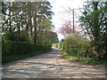
Hillside
On the road from Droxford to Hill Top
Image: © Margaret Sutton
Taken: 14 Apr 2007
0.05 miles
2
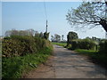
Park Lane
The road from Hill Top to Droxford.
Image: © Margaret Sutton
Taken: 14 Apr 2007
0.06 miles
3
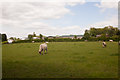
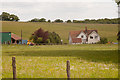
Field on Lycroft Farm, Park Lane
With units of Lycroft Farm Business Park beyond.
Image: © Peter Facey
Taken: 2 Jun 2013
0.09 miles
4
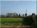
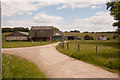
Lycroft Farm
On the road from Hill Top to Droxford
Image: © Margaret Sutton
Taken: 14 Apr 2007
0.11 miles
7
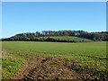
West end of Shepherds Down
A public footpath follows the near hedgerow and a public track the far one.
Image: © Robin Webster
Taken: 6 Dec 2014
0.24 miles