IMAGES TAKEN NEAR TO
Grange Farm Business Park, Sandy Lane, SOUTHAMPTON, SO32 2HD
Introduction
This page details the photographs taken nearby to Grange Farm Business Park, Sandy Lane, SO32 2HD by members of the Geograph project.
The Geograph project started in 2005 with the aim of publishing, organising and preserving representative images for every square kilometre of Great Britain, Ireland and the Isle of Man.

There are currently over 7.5m images from over14,400 individuals and you can help contribute to the project by visiting https://www.geograph.org.uk
Image Map
Images are licensed for reuse under creativecommons.org/licenses/by-sa/2.0
Notes
- Clicking on the map will re-center to the selected point.
- The higher the marker number, the further away the image location is from the centre of the postcode.
Image Listing (6 Images Found)
Images are licensed for reuse under creativecommons.org/licenses/by-sa/2.0
Image
Details
Distance
1
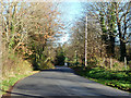
Sandy Lane
It serves a country club, so it is rather busier than might be expected.
Image: © Robin Webster
Taken: 6 Dec 2014
0.12 miles
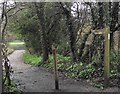
3
Sandy Lane
A footpath leaves on the left, threading through a golf course to the A334.
Image: © Robin Webster
Taken: 6 Dec 2014
0.14 miles
4
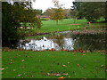
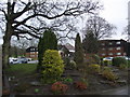
Golf course pond
Nice bit of habitat, golf course adds to the list of urban fringe land uses
Image: © Hugh Venables
Taken: 12 Nov 2005
0.16 miles
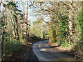
6
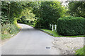
Sandy Lane crossing a stream, nr Waltham Chase
The stream was almost dry. The lane is single track.
Image: © Peter Facey
Taken: 16 Aug 2006
0.18 miles