IMAGES TAKEN NEAR TO
Durley Mews, SOUTHAMPTON, SO32 2ER
Introduction
This page details the photographs taken nearby to Durley Mews, SO32 2ER by members of the Geograph project.
The Geograph project started in 2005 with the aim of publishing, organising and preserving representative images for every square kilometre of Great Britain, Ireland and the Isle of Man.

There are currently over 7.5m images from over14,400 individuals and you can help contribute to the project by visiting https://www.geograph.org.uk
Image Map
Images are licensed for reuse under creativecommons.org/licenses/by-sa/2.0
Notes
- Clicking on the map will re-center to the selected point.
- The higher the marker number, the further away the image location is from the centre of the postcode.
Image Listing (4 Images Found)
Images are licensed for reuse under creativecommons.org/licenses/by-sa/2.0
Image
Details
Distance
1
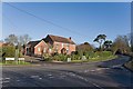
Junction between Durley Brook Road, Durley Street and Parsonage Lane
Here, Durley Brook Road (left) runs smoothly into Durley Street (right) whilst Parsonage Lane joins at rightangles. The house opposite is named Rodlands.
Image: © Peter Facey
Taken: 29 Dec 2007
0.17 miles
2
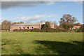
Durley Memorial Hall
The back of it, seen from footpath. With solar panels on the roof at the left end, and temporary scaffolding at the right end. The field is part of Shadyoaks Farm.
Image: © Peter Facey
Taken: 27 Nov 2011
0.20 miles
3
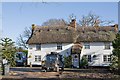
White Owl Cottage, Parsonage Lane, Durley
Image: © Peter Facey
Taken: 29 Dec 2007
0.21 miles
4
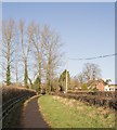
Path beside Parsonage Lane, Durley
About to pass the thatched White Owl Cottage on right. The path takes one to the memorial hall on Durley Brook Road.
Image: © Peter Facey
Taken: 29 Dec 2007
0.25 miles