IMAGES TAKEN NEAR TO
The Hangers, SOUTHAMPTON, SO32 1FZ
Introduction
This page details the photographs taken nearby to The Hangers, SO32 1FZ by members of the Geograph project.
The Geograph project started in 2005 with the aim of publishing, organising and preserving representative images for every square kilometre of Great Britain, Ireland and the Isle of Man.

There are currently over 7.5m images from over14,400 individuals and you can help contribute to the project by visiting https://www.geograph.org.uk
Image Map
Images are licensed for reuse under creativecommons.org/licenses/by-sa/2.0
Notes
- Clicking on the map will re-center to the selected point.
- The higher the marker number, the further away the image location is from the centre of the postcode.
Image Listing (13 Images Found)
Images are licensed for reuse under creativecommons.org/licenses/by-sa/2.0
Image
Details
Distance
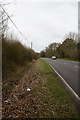
1
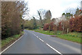
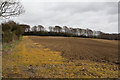
B3035 The Hangers
Towards Meonstoke. The Hangers is the wood on the left, which clothes a steep slope, the road being along a ridge.
Image: © Robin Webster
Taken: 1 Mar 2020
0.02 miles
2
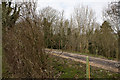
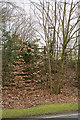
Track in The Hangers woodland
This narrow strip of woodland runs parallel to the B3035. Within it is this private track which is also exactly parallel to the road.
Image: © Peter Facey
Taken: 27 Mar 2010
0.03 miles
3
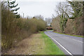
B3035 with The Hangers woodland on right
Image: © Peter Facey
Taken: 27 Mar 2010
0.05 miles
4
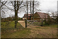
House named Beeches on B3035
Seen from footpath.
Image: © Peter Facey
Taken: 27 Mar 2010
0.08 miles
5
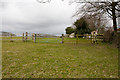
Field on Galley Down
Seen from footpath.
Image: © Peter Facey
Taken: 27 Mar 2010
0.10 miles
6
Footpath leaves B3035 at Beeches
Not so obvious if you don't know it's there. The house ahead left is named Beeches. The footpath descends Galley Down via Bishops Down Farm to Dundridge Lane.
Image: © Peter Facey
Taken: 27 Mar 2010
0.11 miles
7
Footpath cresting Galley Down
As it approaches (on its right) a house named Beeches.
Image: © Peter Facey
Taken: 27 Mar 2010
0.11 miles
8
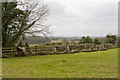
Field and stumps
Seen from footpath south of house named Beeches. The trees had presumably been uprooted by JCB from elsewhere. I wondered why they had been placed here. Beyond one is looking across the valley containing Dundridge Lane towards Bishop's Waltham.
Image: © Peter Facey
Taken: 27 Mar 2010
0.14 miles
9
Newly cleared out ditch beside B3035
West of property named Beeches. The heavily overgrown ditch had been cleared as far as the red car, whence it continued in its overgrown state.
Image: © Peter Facey
Taken: 27 Mar 2010
0.15 miles
10
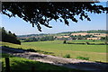
View of farmland from The Hangers (1)
Image: © Barry Shimmon
Taken: 2 Sep 2011
0.16 miles