IMAGES TAKEN NEAR TO
Warsash Road, SOUTHAMPTON, SO31 9NZ
Introduction
This page details the photographs taken nearby to Warsash Road, SO31 9NZ by members of the Geograph project.
The Geograph project started in 2005 with the aim of publishing, organising and preserving representative images for every square kilometre of Great Britain, Ireland and the Isle of Man.

There are currently over 7.5m images from over14,400 individuals and you can help contribute to the project by visiting https://www.geograph.org.uk
Image Map
Images are licensed for reuse under creativecommons.org/licenses/by-sa/2.0
Notes
- Clicking on the map will re-center to the selected point.
- The higher the marker number, the further away the image location is from the centre of the postcode.
Image Listing (15 Images Found)
Images are licensed for reuse under creativecommons.org/licenses/by-sa/2.0
Image
Details
Distance
1
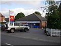
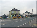
Tesco Express
If it's so convenient, why do so many people drive to it - not a dig at Tesco's but at the car culture. It's amazing what can be done with two legs and a rucksack.
Image: © Hugh Venables
Taken: 31 Aug 2006
0.01 miles
2
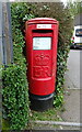
Elizabeth II postbox on Warsash Road
Postbox No. S031 121.
Image: © JThomas
Taken: 27 Apr 2022
0.01 miles
5
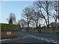
Warsash Road junction with Raley Road
At this crossroads Fleet End Road is straight across.
Image: © Stuart Logan
Taken: 10 Jan 2013
0.11 miles
6
Junction of Monterey Drive and Locks Road
Image: © Basher Eyre
Taken: 5 Dec 2014
0.16 miles
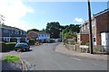
7
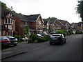
Yet more new housing
This area was clearly ear-marked for development a few years ago. They would mostly, if not all, have been on greenfield sites.
Image: © Hugh Venables
Taken: 31 Aug 2006
0.18 miles
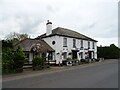
8
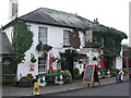
The Jolly Farmer
It looks as good inside as it does from without and the welcome matches the appearance. Food is good and plentiful, beer's well kept - a country pub in an urban setting. The building itself is Grade II listed dating from the early 19th C with English Heritage Building ID: 141580.
Image: © Stuart Logan
Taken: 10 Jan 2013
0.19 miles