IMAGES TAKEN NEAR TO
Dibles Road, SOUTHAMPTON, SO31 9HZ
Introduction
This page details the photographs taken nearby to Dibles Road, SO31 9HZ by members of the Geograph project.
The Geograph project started in 2005 with the aim of publishing, organising and preserving representative images for every square kilometre of Great Britain, Ireland and the Isle of Man.

There are currently over 7.5m images from over14,400 individuals and you can help contribute to the project by visiting https://www.geograph.org.uk
Image Map
Images are licensed for reuse under creativecommons.org/licenses/by-sa/2.0
Notes
- Clicking on the map will re-center to the selected point.
- The higher the marker number, the further away the image location is from the centre of the postcode.
Image Listing (17 Images Found)
Images are licensed for reuse under creativecommons.org/licenses/by-sa/2.0
Image
Details
Distance
1
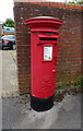
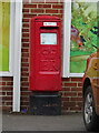
Elizabeth II postbox on Dibles Road
Postbox No. S031 294.
Image: © JThomas
Taken: 27 Apr 2022
0.02 miles
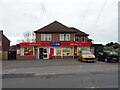
2
Butchers and hairdressers in Warsash Road
Image: © Barry Shimmon
Taken: 24 Sep 2009
0.03 miles
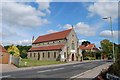
5
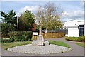
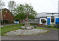
War Memorial in front of Victory Hall
Image: © Barry Shimmon
Taken: 24 Sep 2009
0.15 miles
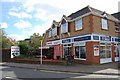
6
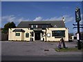
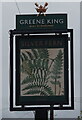
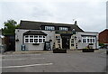
Silver Fern Public House-Warsash
I cannot comment on this pub as I have never been in there.
Image: © Colin Babb
Taken: 1 Apr 2008
0.19 miles
9
Elizabeth II postbox on Warsash Road
No. S031 236.
Image: © JThomas
Taken: 27 Apr 2022
0.20 miles