IMAGES TAKEN NEAR TO
Garden Mews, SOUTHAMPTON, SO31 9GW
Introduction
This page details the photographs taken nearby to Garden Mews, SO31 9GW by members of the Geograph project.
The Geograph project started in 2005 with the aim of publishing, organising and preserving representative images for every square kilometre of Great Britain, Ireland and the Isle of Man.

There are currently over 7.5m images from over14,400 individuals and you can help contribute to the project by visiting https://www.geograph.org.uk
Image Map
Images are licensed for reuse under creativecommons.org/licenses/by-sa/2.0
Notes
- Clicking on the map will re-center to the selected point.
- The higher the marker number, the further away the image location is from the centre of the postcode.
Image Listing (70 Images Found)
Images are licensed for reuse under creativecommons.org/licenses/by-sa/2.0
Image
Details
Distance

3
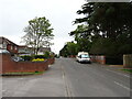
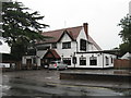
Houses in Newtown Road.
Just south of the centre of Warsash this road is lined with an attractive collection of brick detached and semi-detached houses, all somewhat different from their neighbours.
Image: © David Martin
Taken: 11 May 2012
0.07 miles
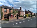
5
Old Cottages-Shore Road-Warsash
These old cottages make a nice change from all the large surrounding modern houses. Warsash Clock Tower is seen in the distance.
Image: © Colin Babb
Taken: 1 Apr 2008
0.10 miles
6

The clocktower, Warsash
The Edwardian clocktower provides a local landmark at the crossroads in the centre of the village. One square to the west Image is Warsash's waterfront on the River Hamble.
Image: © Peter Jordan
Taken: 30 Sep 2005
0.12 miles
8
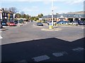
Cross Roads at Warsash
View looking North at Warsash roundabout. Brook Lane ahead, Warsash Road to the right, Shore Road to the left.
Image: © Colin Babb
Taken: 1 Apr 2008
0.12 miles
9
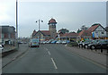
Warsash Road junction with Brook Lane
This crossroads is the epicentre of Warsash. The original hamlet expanded into a village because of a local shipyard started on the banks of the nearby Hamble River in the early 19th C. Newtown Road is on the left and leads to the Warsash Maritime Academy. The clock tower was originally built to disguise a 6,000 gallon water tank.
Image: © Stuart Logan
Taken: 10 Jan 2013
0.12 miles
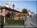
10
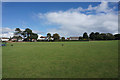
Strawberry Fields
A Hampshire County Council countryside site. It does maintain a good aspect for the houses ahead down towards the River Hamble.
Image: © Bill Boaden
Taken: 30 Sep 2016
0.12 miles