IMAGES TAKEN NEAR TO
Thornton Avenue, SOUTHAMPTON, SO31 9FJ
Introduction
This page details the photographs taken nearby to Thornton Avenue, SO31 9FJ by members of the Geograph project.
The Geograph project started in 2005 with the aim of publishing, organising and preserving representative images for every square kilometre of Great Britain, Ireland and the Isle of Man.

There are currently over 7.5m images from over14,400 individuals and you can help contribute to the project by visiting https://www.geograph.org.uk
Image Map
Images are licensed for reuse under creativecommons.org/licenses/by-sa/2.0
Notes
- Clicking on the map will re-center to the selected point.
- The higher the marker number, the further away the image location is from the centre of the postcode.
Image Listing (43 Images Found)
Images are licensed for reuse under creativecommons.org/licenses/by-sa/2.0
Image
Details
Distance
2
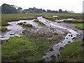
Saltmarsh at Warsash
Known as Bunny Meadows, this was once poor quality grazing land, but since 1946, has been allowed to be flooded.
This was done by installing culverts under the river embankment on which the photographer is standing.
Image: © Richard Dorrell
Taken: 1 Aug 2009
0.14 miles
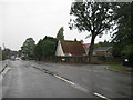
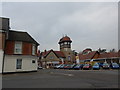
9

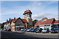
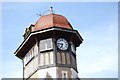
The clocktower, Warsash
The Edwardian clocktower provides a local landmark at the crossroads in the centre of the village. One square to the west Image is Warsash's waterfront on the River Hamble.
Image: © Peter Jordan
Taken: 30 Sep 2005
0.18 miles
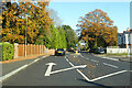
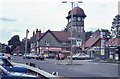
10
Crossroads of Newtown, Shore and Warsash Roads with Brook Lane
Image: © Basher Eyre
Taken: 3 Apr 2014
0.18 miles