IMAGES TAKEN NEAR TO
Stewart Close, SOUTHAMPTON, SO31 8NU
Introduction
This page details the photographs taken nearby to Stewart Close, SO31 8NU by members of the Geograph project.
The Geograph project started in 2005 with the aim of publishing, organising and preserving representative images for every square kilometre of Great Britain, Ireland and the Isle of Man.

There are currently over 7.5m images from over14,400 individuals and you can help contribute to the project by visiting https://www.geograph.org.uk
Image Map
Images are licensed for reuse under creativecommons.org/licenses/by-sa/2.0
Notes
- Clicking on the map will re-center to the selected point.
- The higher the marker number, the further away the image location is from the centre of the postcode.
Image Listing (24 Images Found)
Images are licensed for reuse under creativecommons.org/licenses/by-sa/2.0
Image
Details
Distance
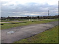
1

Looking back over Bursledon Market car park
Looking back over Bursledon Market car park public footpath towards Hamble Lane
Image: © dinglefoot
Taken: 31 Dec 2009
0.01 miles
2

A track Into a soggy footpath
Green lane turns into a Soggy path towards Bursledon Road.
Image: © dinglefoot
Taken: 31 Dec 2009
0.07 miles
3

Green Lane track
This is Green Lane; in about 400 yards from here track turns into footpath.
Image: © dinglefoot
Taken: 31 Dec 2009
0.07 miles
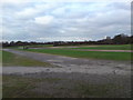
4
Bursledon Car Boot Car Park
Bursledon Car Boot car park has a public footpath running diagonally across it.
The path runs through the sets of white posts, across to a stile in the far corner.
This car park is also used as "Park & Ride" parking area, when Southampton FC are playing at home.
Image: © dinglefoot
Taken: 31 Dec 2009
0.08 miles
5

Footpath becomes a little lost
Footpath north to Bursledon Road becomes a little lost here.
Image: © dinglefoot
Taken: 31 Dec 2009
0.09 miles
6
The site of Bursledon Car Boot & Sunday Market
This is the site of Bursledon Car Boot & Sunday Market.
Open all year it attracts 1000s buyers & sellers each Sunday at 7am
Image: © dinglefoot
Taken: 31 Dec 2009
0.10 miles
7

Footpath & Car Boot exit
Taken from Bursledon Road the footpath widens considerably to double up as a car boot sale second exit.
Image: © dinglefoot
Taken: 31 Dec 2009
0.12 miles
8

Footpath to Shop Lane
This is the start of the public footpath from Green lane to Shop lane
Image: © dinglefoot
Taken: 31 Dec 2009
0.13 miles
9

Crop field view to hamble Lane
Looking over this crop field to the busy Hamble Lane. You can just about see a red sign of a busy 24 hour Tesco Extra Superstore. Living here this is your corner shop! What estate agents would describe as "Semi Rural" is possibly right!
Image: © dinglefoot
Taken: 31 Dec 2009
0.14 miles
10
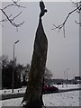
Tree Totem Pole Hamble Lane
This pine tree was carved with chainsaws a few years ago. It has the BP logo carved into it. I think it may have been commissioned by BP who have a depot in Hamble.
Image: © dinglefoot
Taken: 11 Jan 2010
0.15 miles