IMAGES TAKEN NEAR TO
Heath Road North, SOUTHAMPTON, SO31 7PP
Introduction
This page details the photographs taken nearby to Heath Road North, SO31 7PP by members of the Geograph project.
The Geograph project started in 2005 with the aim of publishing, organising and preserving representative images for every square kilometre of Great Britain, Ireland and the Isle of Man.

There are currently over 7.5m images from over14,400 individuals and you can help contribute to the project by visiting https://www.geograph.org.uk
Image Map
Images are licensed for reuse under creativecommons.org/licenses/by-sa/2.0
Notes
- Clicking on the map will re-center to the selected point.
- The higher the marker number, the further away the image location is from the centre of the postcode.
Image Listing (7 Images Found)
Images are licensed for reuse under creativecommons.org/licenses/by-sa/2.0
Image
Details
Distance
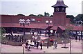
1
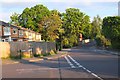
Strawberry Hill, Locks Heath
The junction of Strawberry Hill (L) and Heath Road North. The name recalls the times when growing strawberries was an important local industry - see http://www.locksheath.com/index.php/local-history.
Image: © Jim Barton
Taken: 16 May 2016
0.06 miles
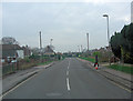
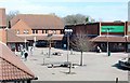
4
Road reconstruction
Access road reconstruction associated with a new housing development in Coldeast Way, just visible through the trees.
Image: © David Martin
Taken: 11 May 2012
0.22 miles
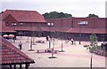
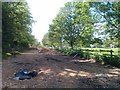
7
Seating and play area at Locks Heath Shopping Centre
Image: © Barry Shimmon
Taken: 4 Jun 1984
0.25 miles