IMAGES TAKEN NEAR TO
Uxbridge Close, SOUTHAMPTON, SO31 7LP
Introduction
This page details the photographs taken nearby to Uxbridge Close, SO31 7LP by members of the Geograph project.
The Geograph project started in 2005 with the aim of publishing, organising and preserving representative images for every square kilometre of Great Britain, Ireland and the Isle of Man.

There are currently over 7.5m images from over14,400 individuals and you can help contribute to the project by visiting https://www.geograph.org.uk
Image Map
Images are licensed for reuse under creativecommons.org/licenses/by-sa/2.0
Notes
- Clicking on the map will re-center to the selected point.
- The higher the marker number, the further away the image location is from the centre of the postcode.
Image Listing (19 Images Found)
Images are licensed for reuse under creativecommons.org/licenses/by-sa/2.0
Image
Details
Distance
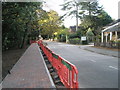
1
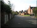
Junction of Ironbridge Crescent and Edenbridge Way
Looking down towards the A27
Image: © Basher Eyre
Taken: 10 Nov 2007
0.05 miles
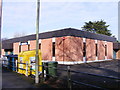
2
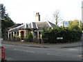
Veterinary Surgeons in Coldeast Way
The very most eastern feature in this square.
Image: © Basher Eyre
Taken: 10 Nov 2007
0.06 miles
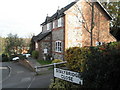
3
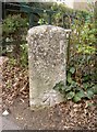
Old Milestone by the A27, Bridge Road, Sarisbury
Stone post by the A27, Bridge Road, Sarisbury; Eastligh District, Parish of Bursledon. By No. 98 Bridge Road, house name Jeanette, North side of road.
Inscription once read:-
(Southampton)
(7)
Carved bench mark on lower face.
Milestone Society National ID: HA_SOHA07
Image: © K Lawrence
Taken: 29 Mar 2003
0.06 miles
4
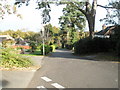
Junction of Ironbridge Crescent and the A27
A very busy road between Park Gate and Sarisbury
Image: © Basher Eyre
Taken: 10 Nov 2007
0.06 miles
5
At the very western edge of the grid square
Looking down Coldeast Way - the building you can see on the right of the picture is a veterinary surgeons.
Image: © Basher Eyre
Taken: 10 Nov 2007
0.07 miles
7
Detached house in Stalybridge Close
The traditional style disguises the newness of the property.
Image: © Basher Eyre
Taken: 10 Nov 2007
0.12 miles
8
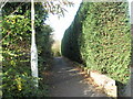
Footpath between Beacon Bottom and Stalybridge Close
Not marked on the map but definitely a public right of way.
Image: © Basher Eyre
Taken: 10 Nov 2007
0.12 miles
9
Junction of Beacon Way and Beacon Bottom
At this spot it was less clear that we were in the middle of a modern housing estate.
Image: © Basher Eyre
Taken: 10 Nov 2007
0.15 miles
10
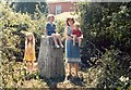
Family relaxing at local trig point
Park Gate triangulation pillar described at http://trigpointinguk.com/trigs/trig-details.php?t=5308
Image: © Roger Templeman
Taken: 24 Jul 1985
0.16 miles