IMAGES TAKEN NEAR TO
Coal Park Lane, SOUTHAMPTON, SO31 7GW
Introduction
This page details the photographs taken nearby to Coal Park Lane, SO31 7GW by members of the Geograph project.
The Geograph project started in 2005 with the aim of publishing, organising and preserving representative images for every square kilometre of Great Britain, Ireland and the Isle of Man.

There are currently over 7.5m images from over14,400 individuals and you can help contribute to the project by visiting https://www.geograph.org.uk
Image Map
Images are licensed for reuse under creativecommons.org/licenses/by-sa/2.0
Notes
- Clicking on the map will re-center to the selected point.
- The higher the marker number, the further away the image location is from the centre of the postcode.
Image Listing (45 Images Found)
Images are licensed for reuse under creativecommons.org/licenses/by-sa/2.0
Image
Details
Distance
1
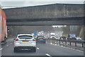
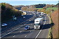
Borough of Fareham : M27 Motorway
The M27 Motorway between Junction 8 (Windhover Interchange) and Junction 9 (Park Gate Interchange).
Image: © Lewis Clarke
Taken: 28 Mar 2018
0.03 miles
4
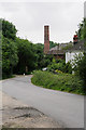
Coal Park Lane, Swanwick
The white house is named Ferndale. The chimney is part of Bursledon Brickworks, now a museum. This section of the lane is sandwiched between the M27 and the railway.
Image: © Peter Facey
Taken: 12 Jun 2007
0.07 miles
5
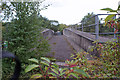
Disused bridge, Bursledon Brickworks
This bridge spans the M27 motorway. The bridge was built under an aerial ropeway which was used to transport clay from the nearby clay pits to the brickworks - the bridge being there to protect traffic below from anything dropping from the ropeway. The brickworks closed in 1974, before the then newly built motorway was opened to traffic, so the bridge was never actually needed. Bursledon Brickworks is now an industrial museum.
Image: © Richard Dorrell
Taken: 8 Sep 2015
0.08 miles
6
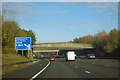
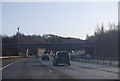
M27 - junction 8 in one mile
The near bridges formerly connected a brickworks and brickfields that were cut in two by the motorway. They seen to be redundant now, as the works has commercially closed, becoming an industrial museum to the left and being built on by an air traffic control centre to the right.
Image: © Robin Webster
Taken: 30 Oct 2012
0.08 miles
7
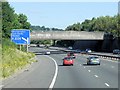
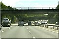
Concrete Bridge over the M27
The bridge originally connected a brickworks (now the Bursledon Brickworks Industrial Museum) with brickfields (now the site of an air traffic control centre) on the opposite side of the motorway.
Image: © David Dixon
Taken: 20 Jul 2013
0.09 miles
8
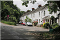
Houses in Coal Park Lane, Swanwick
The lane goes up the hill at left of picture to the railway bridge.
Image: © Peter Facey
Taken: 12 Jun 2007
0.09 miles
9

Bursledon Brickworks Industrial Museum - steam engine
This is a recreation of a small 'estate size' steam powered brickworks. The engine is an inverted vertical single cylinder by S S Stott of Haslingden and was used at Winchester refuse destructor before spending some years at Poldark Mine in Cornwall.
Image: © Chris Allen
Taken: 23 Oct 2011
0.09 miles
10
M27 motorway just east of the River Hamble
Image: © David Martin
Taken: 26 Nov 2018
0.10 miles