IMAGES TAKEN NEAR TO
Bridge Road, SOUTHAMPTON, SO31 7ED
Introduction
This page details the photographs taken nearby to Bridge Road, SO31 7ED by members of the Geograph project.
The Geograph project started in 2005 with the aim of publishing, organising and preserving representative images for every square kilometre of Great Britain, Ireland and the Isle of Man.

There are currently over 7.5m images from over14,400 individuals and you can help contribute to the project by visiting https://www.geograph.org.uk
Image Map
Images are licensed for reuse under creativecommons.org/licenses/by-sa/2.0
Notes
- Clicking on the map will re-center to the selected point.
- The higher the marker number, the further away the image location is from the centre of the postcode.
Image Listing (16 Images Found)
Images are licensed for reuse under creativecommons.org/licenses/by-sa/2.0
Image
Details
Distance
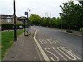
6
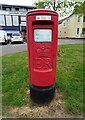
Elizabeth II postbox on Bridge Road
Postbox No. S031 292.
Image: © JThomas
Taken: 27 Apr 2022
0.21 miles
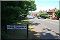
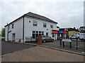
7
Local Shops - Sarisbury Green
The cream building next to One Stop used to be the Post Office.
Image: © Colin Babb
Taken: 8 Apr 2008
0.22 miles
8
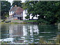
House bordering the River Hamble near Swanwick
Image: © Gillian Thomas
Taken: 31 Aug 2011
0.23 miles
9
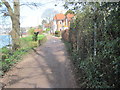
Footpath beside River Hamble near Lower Swanwick
Image: © Chris Wimbush
Taken: 13 Mar 2017
0.23 miles