IMAGES TAKEN NEAR TO
Bridge Road, SOUTHAMPTON, SO31 7EB
Introduction
This page details the photographs taken nearby to Bridge Road, SO31 7EB by members of the Geograph project.
The Geograph project started in 2005 with the aim of publishing, organising and preserving representative images for every square kilometre of Great Britain, Ireland and the Isle of Man.

There are currently over 7.5m images from over14,400 individuals and you can help contribute to the project by visiting https://www.geograph.org.uk
Image Map
Images are licensed for reuse under creativecommons.org/licenses/by-sa/2.0
Notes
- Clicking on the map will re-center to the selected point.
- The higher the marker number, the further away the image location is from the centre of the postcode.
Image Listing (93 Images Found)
Images are licensed for reuse under creativecommons.org/licenses/by-sa/2.0
Image
Details
Distance
1
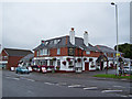
The Spinnaker Inn, Bridge Road, Lower Swanwick
Hotel, restaurant and bar hosting regular live music.
Image: © Richard Dorrell
Taken: 1 Aug 2009
0.00 miles
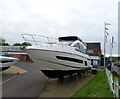
3
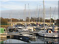
R K Marine
On River Hamble at Bursledon Bridge. Seen from the bridge.
Image: © Peter Facey
Taken: 27 Jun 2009
0.05 miles
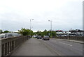
5
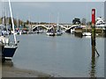
Bursledon Bridge
The A27 crosses the River Hamble at Deacons Marina.
Image: © M J Richardson
Taken: 26 Nov 2017
0.10 miles
7
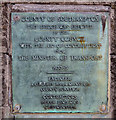
Plaque on Bursledon Bridge
The bridge carries the A27 (Bridge Road) over the River Hamble. The plaque reads
COUNTY OF SOUTHAMPTON
This bridge was erected
by the
COUNTY COUNCIL
with the aid of contributions from
THE MINISTER OF TRANSPORT
1933-35
ENGINEER A. C. Hughes, County Surveyor
CONTRACTORS Peter Lind & Co, Westminster
Southampton is of course within the county of Hampshire but in 1997 it became a unitary authority and thus is an administrative county. I was not aware that Southampton was also a county in 1933.
Image: © Peter Facey
Taken: 27 Jun 2009
0.10 miles
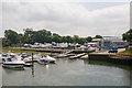
8
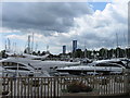
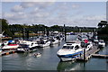
Navigable part of River Hamble north of Bursledon Bridge
The Hamble is considerably narrowed here due to the moorings extending from left and right banks, leaving this narrow central channel for navigation. The railway bridge is beyond.
Image: © Peter Facey
Taken: 27 Jun 2009
0.10 miles
9
The Hamble leading to Bursledon Bridge
Taken from the jetty belonging to Image] looking up the River Hamble to Bursledon Bridge which carries the A27 over the river.
Image: © Rob Farrow
Taken: 16 Apr 2015
0.11 miles
10
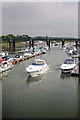
River Hamble
View towards the railway bridge at Bursledon.
Image: © Peter Trimming
Taken: 15 Aug 2019
0.11 miles