IMAGES TAKEN NEAR TO
Allotment Road, SOUTHAMPTON, SO31 7AP
Introduction
This page details the photographs taken nearby to Allotment Road, SO31 7AP by members of the Geograph project.
The Geograph project started in 2005 with the aim of publishing, organising and preserving representative images for every square kilometre of Great Britain, Ireland and the Isle of Man.

There are currently over 7.5m images from over14,400 individuals and you can help contribute to the project by visiting https://www.geograph.org.uk
Image Map
Images are licensed for reuse under creativecommons.org/licenses/by-sa/2.0
Notes
- Clicking on the map will re-center to the selected point.
- The higher the marker number, the further away the image location is from the centre of the postcode.
Image Listing (28 Images Found)
Images are licensed for reuse under creativecommons.org/licenses/by-sa/2.0
Image
Details
Distance
1
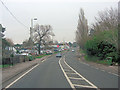
A27 Bridge Road passes The Bold Forester
Image: © Stuart Logan
Taken: 10 Jan 2013
0.09 miles
2
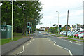
A27 Bridge Road, Sarisbury
Towards Southampton.
Image: © Robin Webster
Taken: 16 Sep 2018
0.10 miles
3
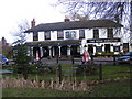
The Bold Forester public house
The pub is on Bridge Road
Image: © peter clayton
Taken: 20 Feb 2010
0.13 miles
5
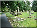
St Paul, Sarisbury Green- crosses in the churchyard
Image: © Basher Eyre
Taken: 11 Sep 2010
0.17 miles
6
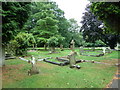
St Paul, Sarisbury Green- early autumn in the churchyard
Image: © Basher Eyre
Taken: 11 Sep 2010
0.19 miles
7
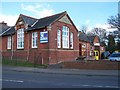
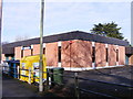
Converted School - Sarisbury Green
Now a wholesale distributor.
Image: © Colin Babb
Taken: 8 Apr 2008
0.19 miles
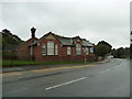
10
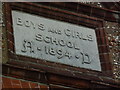
Date stone on the former school in Barnes Lane
Image: © Basher Eyre
Taken: 11 Sep 2010
0.19 miles