IMAGES TAKEN NEAR TO
Kingfisher Copse, SOUTHAMPTON, SO31 6WT
Introduction
This page details the photographs taken nearby to Kingfisher Copse, SO31 6WT by members of the Geograph project.
The Geograph project started in 2005 with the aim of publishing, organising and preserving representative images for every square kilometre of Great Britain, Ireland and the Isle of Man.

There are currently over 7.5m images from over14,400 individuals and you can help contribute to the project by visiting https://www.geograph.org.uk
Image Map
Images are licensed for reuse under creativecommons.org/licenses/by-sa/2.0
Notes
- Clicking on the map will re-center to the selected point.
- The higher the marker number, the further away the image location is from the centre of the postcode.
Image Listing (7 Images Found)
Images are licensed for reuse under creativecommons.org/licenses/by-sa/2.0
Image
Details
Distance
1
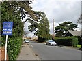
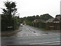
Church Road, Locks Heath
Well past the church, looking west.
Image: © Robin Webster
Taken: 21 Nov 2021
0.05 miles
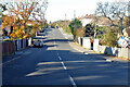
2
New Housing
One of the many small/medium sized new housing developments in the area.
Image: © Hugh Venables
Taken: 31 Aug 2006
0.14 miles
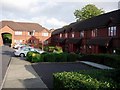
4
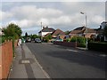
Housing mix
Many different ages and styles of housing in the area - some 'bungaloid' developments, probably targeted at the retirement market and some larger houses.
Image: © Hugh Venables
Taken: 31 Aug 2006
0.23 miles
5
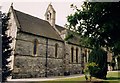
St John the Baptist, Locks Heath
Built in 1895.
Image: © Michael FORD
Taken: Unknown
0.24 miles