IMAGES TAKEN NEAR TO
Sloetree Close, SOUTHAMPTON, SO31 6RP
Introduction
This page details the photographs taken nearby to Sloetree Close, SO31 6RP by members of the Geograph project.
The Geograph project started in 2005 with the aim of publishing, organising and preserving representative images for every square kilometre of Great Britain, Ireland and the Isle of Man.

There are currently over 7.5m images from over14,400 individuals and you can help contribute to the project by visiting https://www.geograph.org.uk
Image Map
Images are licensed for reuse under creativecommons.org/licenses/by-sa/2.0
Notes
- Clicking on the map will re-center to the selected point.
- The higher the marker number, the further away the image location is from the centre of the postcode.
Image Listing (10 Images Found)
Images are licensed for reuse under creativecommons.org/licenses/by-sa/2.0
Image
Details
Distance
2
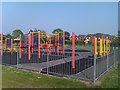
Colourful playground next to Abshot Road
Image: © David Martin
Taken: 24 May 2012
0.14 miles
4
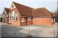
Titchfield Common, Hampshire
St John The Baptist Primary School
Image: © Brendan and Ruth McCartney
Taken: 23 Oct 2011
0.15 miles
8
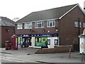
Titchfield Common: the post office
One of several post offices in the area destined for closure in January 2008.
Image: © Chris Downer
Taken: 1 Dec 2007
0.22 miles
9
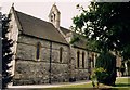
St John the Baptist, Locks Heath
Built in 1895.
Image: © Michael FORD
Taken: Unknown
0.23 miles
10
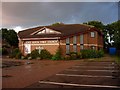
Locks Heath Free Church
With a small poster offering a course that will teach you the meaning of life. Personally, if I'd worked that out I'd make more of a fuss about it.
Image: © Hugh Venables
Taken: 24 Aug 2006
0.25 miles