IMAGES TAKEN NEAR TO
Chichester Close, SOUTHAMPTON, SO31 6EX
Introduction
This page details the photographs taken nearby to Chichester Close, SO31 6EX by members of the Geograph project.
The Geograph project started in 2005 with the aim of publishing, organising and preserving representative images for every square kilometre of Great Britain, Ireland and the Isle of Man.

There are currently over 7.5m images from over14,400 individuals and you can help contribute to the project by visiting https://www.geograph.org.uk
Image Map
Images are licensed for reuse under creativecommons.org/licenses/by-sa/2.0
Notes
- Clicking on the map will re-center to the selected point.
- The higher the marker number, the further away the image location is from the centre of the postcode.
Image Listing (12 Images Found)
Images are licensed for reuse under creativecommons.org/licenses/by-sa/2.0
Image
Details
Distance
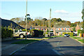
1
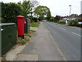
Brook Lane
Showing position of Postbox No. S031 184.
Image: © JThomas
Taken: 27 Apr 2022
0.11 miles
2
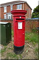
Elizabeth II postbox on Brook Lane
Postbox No. S031 184.
Image: © JThomas
Taken: 27 Apr 2022
0.11 miles
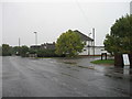
3
Food Outlets, Junction Barnes Lane & Holly Close
If you are hungry, then you are spoiled for choice here.Thai, Balti, Chinese and Indian.All next door to each other, and in the middle, a wine shop as well.
Image: © Colin Babb
Taken: 8 Apr 2008
0.12 miles
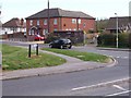
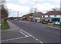
9
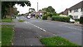
Barnes Lane
At the junction with Winnard's Park.
Image: © David Martin
Taken: 20 Sep 2017
0.16 miles
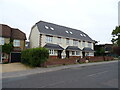
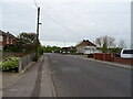
10
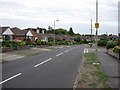
Barnbrook Road
A typical 'bungaloid' development in a coastal area popular with retired people.
Image: © Hugh Venables
Taken: 24 Aug 2006
0.20 miles