IMAGES TAKEN NEAR TO
Wykeham Road, SOUTHAMPTON, SO31 5EQ
Introduction
This page details the photographs taken nearby to Wykeham Road, SO31 5EQ by members of the Geograph project.
The Geograph project started in 2005 with the aim of publishing, organising and preserving representative images for every square kilometre of Great Britain, Ireland and the Isle of Man.

There are currently over 7.5m images from over14,400 individuals and you can help contribute to the project by visiting https://www.geograph.org.uk
Image Map
Images are licensed for reuse under creativecommons.org/licenses/by-sa/2.0
Notes
- Clicking on the map will re-center to the selected point.
- The higher the marker number, the further away the image location is from the centre of the postcode.
Image Listing (129 Images Found)
Images are licensed for reuse under creativecommons.org/licenses/by-sa/2.0
Image
Details
Distance
1
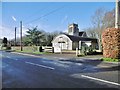
Netley, church hall
On Grange Road, in the grounds of Image
Image: © Mike Faherty
Taken: 18 Jan 2020
0.14 miles
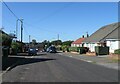

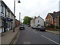
4
Victoria Road, Netley
It's hardly surprising that Netley has so many names which connect to Queen Victoria. She was a fervent supporter of the Royal Victoria Hospital, just to the east, not only laying the foundation stone on 19 May 1856 but also visiting it on a regular basis from then on.
Image: © Stuart Logan
Taken: 15 Sep 2011
0.15 miles

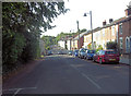
8
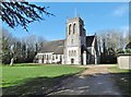
Netley, St. Edward's
Parish church on Grange Road, dating from 1886; Grade II listed by Historic England: https://historicengland.org.uk/listing/the-list/list-entry/1111931
Image: © Mike Faherty
Taken: 18 Jan 2020
0.16 miles
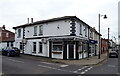
10
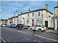
Netley, former Red Lion
A red figure above the door suggests this building was once the Red Lion, on Victoria Road; confirmed by old OS maps.
Image: © Mike Faherty
Taken: 18 Jan 2020
0.16 miles