IMAGES TAKEN NEAR TO
Crowsport, SOUTHAMPTON, SO31 4HG
Introduction
This page details the photographs taken nearby to Crowsport, SO31 4HG by members of the Geograph project.
The Geograph project started in 2005 with the aim of publishing, organising and preserving representative images for every square kilometre of Great Britain, Ireland and the Isle of Man.

There are currently over 7.5m images from over14,400 individuals and you can help contribute to the project by visiting https://www.geograph.org.uk
Image Map
Images are licensed for reuse under creativecommons.org/licenses/by-sa/2.0
Notes
- Clicking on the map will re-center to the selected point.
- The higher the marker number, the further away the image location is from the centre of the postcode.
Image Listing (110 Images Found)
Images are licensed for reuse under creativecommons.org/licenses/by-sa/2.0
Image
Details
Distance
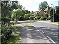
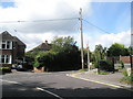
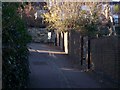
1
Looking from Marina Drive into Crowsport
Image: © Basher Eyre
Taken: 29 Aug 2009
0.06 miles
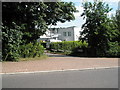
4
Junction of Satchell Lane and Marina Drive
Image: © Basher Eyre
Taken: 29 Aug 2009
0.07 miles
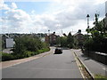
7
Looking from Satchell Lane into Luke's Close
Image: © Basher Eyre
Taken: 29 Aug 2009
0.10 miles
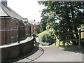
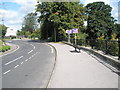
8
Well Lane - Hamble
Where the village of Hamble le Rice got its water at one time.
Image: © Colin Babb
Taken: 28 Dec 2008
0.12 miles
9
Sit on it and you will see!
It looks out from Satchell Lane between two buildings in Luke's Close out into the Hamble.
Image: © Basher Eyre
Taken: 29 Aug 2009
0.12 miles