IMAGES TAKEN NEAR TO
Abbotstone Road, ALRESFORD, SO24 9TD
Introduction
This page details the photographs taken nearby to Abbotstone Road, SO24 9TD by members of the Geograph project.
The Geograph project started in 2005 with the aim of publishing, organising and preserving representative images for every square kilometre of Great Britain, Ireland and the Isle of Man.

There are currently over 7.5m images from over14,400 individuals and you can help contribute to the project by visiting https://www.geograph.org.uk
Image Map
Images are licensed for reuse under creativecommons.org/licenses/by-sa/2.0
Notes
- Clicking on the map will re-center to the selected point.
- The higher the marker number, the further away the image location is from the centre of the postcode.
Image Listing (12 Images Found)
Images are licensed for reuse under creativecommons.org/licenses/by-sa/2.0
Image
Details
Distance
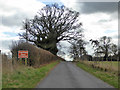
4
Old shed at Fobdown Farm
This may have been used for keeping poultry.
Image: © Shazz
Taken: 6 Apr 2013
0.08 miles
5
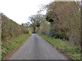
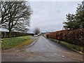
Lane near Fobdown Farm
From Abbotstone to Alresford.
Image: © Robin Webster
Taken: 24 Feb 2017
0.08 miles
6
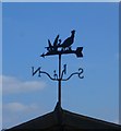
Weatherpheasant at the stables by Fobdown Farm
Image: © Shazz
Taken: 6 Apr 2013
0.11 miles
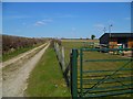
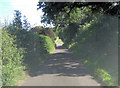
8
Caution farm entrance
The only hazards immediately ahead are field entrances and a single barn.
Image: © Robin Webster
Taken: 24 Feb 2017
0.16 miles
9
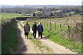
Lane to Fobdown Farm
The Alresford area boasts many fine walking paths including this track which runs NE from Fobdown Farm, seen behind the walkers.
Image: © Peter Standing
Taken: 11 Mar 2007
0.17 miles
10
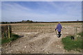
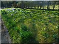
Field near Fobdown
The path NE of Fobdown Farm passes this gateway en route to Abbotstone or Old Alresford
Image: © Peter Standing
Taken: 11 Mar 2007
0.19 miles