IMAGES TAKEN NEAR TO
Old Alresford, ALRESFORD, SO24 9DZ
Introduction
This page details the photographs taken nearby to SO24 9DZ by members of the Geograph project.
The Geograph project started in 2005 with the aim of publishing, organising and preserving representative images for every square kilometre of Great Britain, Ireland and the Isle of Man.

There are currently over 7.5m images from over14,400 individuals and you can help contribute to the project by visiting https://www.geograph.org.uk
Image Map
Images are licensed for reuse under creativecommons.org/licenses/by-sa/2.0
Notes
- Clicking on the map will re-center to the selected point.
- The higher the marker number, the further away the image location is from the centre of the postcode.
Image Listing (11 Images Found)
Images are licensed for reuse under creativecommons.org/licenses/by-sa/2.0
Image
Details
Distance
1
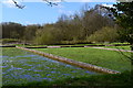
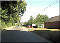
Wandering westwards along the Bashire (30)
Cottages by the water cress farm
Image: © Basher Eyre
Taken: 14 Feb 2023
0.02 miles
2
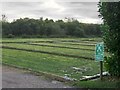
Alresford Salads
Farming concern at Alresford, an area of intensive watercress growing.
www.alresford.org
Image: © Colin Smith
Taken: 13 Aug 2011
0.07 miles
3
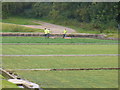
Alresford Salads, Watercress Beds
Intensive market gardening and an old-established industry in the Alre Valley.
www.alresford.org
Image: © Colin Smith
Taken: 13 Aug 2011
0.09 miles
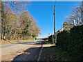
4
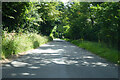
Bighton Lane passes Alresford Salads
There are quite a number of businesses growing watercress in and around Northern Hampshire but New Alresford; not only has a festival devoted to the salad, but also a heritage railway line which one carried the crop to London. The plant is a member of the Brassica family (Nasturtium officinale) and prefers to grow in flowing water that is slightly alkaline. herece the profusion of sites on the chalk downs of the county.
Image: © Stuart Logan
Taken: 7 Sep 2012
0.10 miles
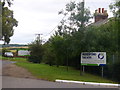
5
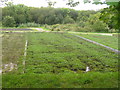
Watercress beds, Old Alresford
This area of the Alre flood-plain is, for the most part, enclosed by high hedges and belts of woodland. There are just a few entrances which give some sort of a view.
The English wording on the bi-lingual notice says 'Fire assembly point'. The wording in Polish is 'Punkt zbiorki ewakuacyjnej', which might be translated as 'Assembly point in case of evacuation', making no explicit reference to fire. There are other notices nearby warning the public that hazardous chemicals are in use on-site. Given the wetness of the site, I wonder whether fire is the real hazard here.
Image: © Stefan Czapski
Taken: 22 Sep 2016
0.13 miles
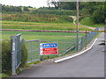
6
Watercress Beds, Alresford Salads
Market gardening in an area of intensive watercress growing at Alresford.
www.alresford.org
Image: © Colin Smith
Taken: 13 Aug 2011
0.18 miles
8
Watercress Beds, Old Alresford
In the Alre Valley, to the north of Old Alresford Pond.
www.alresford.org
Image: © Colin Smith
Taken: 13 Aug 2011
0.20 miles
9

Watercress beds near Alresford
Watercress was a major industry in this area and these beds are still in use.
Image: © Graham Clutton
Taken: 22 Jan 2006
0.20 miles