IMAGES TAKEN NEAR TO
Basingstoke Road, ALRESFORD, SO24 9DS
Introduction
This page details the photographs taken nearby to Basingstoke Road, SO24 9DS by members of the Geograph project.
The Geograph project started in 2005 with the aim of publishing, organising and preserving representative images for every square kilometre of Great Britain, Ireland and the Isle of Man.

There are currently over 7.5m images from over14,400 individuals and you can help contribute to the project by visiting https://www.geograph.org.uk
Image Map
Images are licensed for reuse under creativecommons.org/licenses/by-sa/2.0
Notes
- Clicking on the map will re-center to the selected point.
- The higher the marker number, the further away the image location is from the centre of the postcode.
Image Listing (7 Images Found)
Images are licensed for reuse under creativecommons.org/licenses/by-sa/2.0
Image
Details
Distance
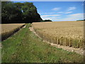
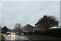
1
Farmland, Old Alresford
A crop of wheat to the west of the B3046.
Image: © Andrew Smith
Taken: 23 Jul 2009
0.03 miles
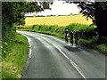
3
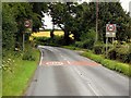
Basingstoke Road entering Old Alresford
Image: © David Dixon
Taken: 19 Jul 2014
0.15 miles
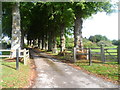
5
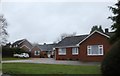
Bungalow on Basingstoke Road, Old Alresford
Image: © David Howard
Taken: 15 Dec 2018
0.21 miles