IMAGES TAKEN NEAR TO
Alresford Road, ALRESFORD, SO24 0QT
Introduction
This page details the photographs taken nearby to Alresford Road, SO24 0QT by members of the Geograph project.
The Geograph project started in 2005 with the aim of publishing, organising and preserving representative images for every square kilometre of Great Britain, Ireland and the Isle of Man.

There are currently over 7.5m images from over14,400 individuals and you can help contribute to the project by visiting https://www.geograph.org.uk
Image Map
Images are licensed for reuse under creativecommons.org/licenses/by-sa/2.0
Notes
- Clicking on the map will re-center to the selected point.
- The higher the marker number, the further away the image location is from the centre of the postcode.
Image Listing (26 Images Found)
Images are licensed for reuse under creativecommons.org/licenses/by-sa/2.0
Image
Details
Distance
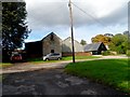
1
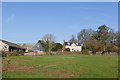
Buildings at Manor Farm, Itchen Stoke
The disused farm buildings at left are gradually being converted for business use.
Image: © Peter Facey
Taken: 13 Nov 2011
0.06 miles
2

Manor Farm, Itchen Stoke, seen from East Lane
The large houser at right is Itchen Stoke Manor. The converted barns at left are the premises of andrew Smith & Sons, auctioneers http://www.andrewsmithandson.com/ .
Image: © Peter Facey
Taken: 13 Nov 2011
0.07 miles

4
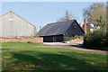
Buildings at Manor Farm, Itchen Stoke
These redundant farm buildings are gradually being converted for business use. The newly-converted black one is named The Old Bull Pens.
Image: © Peter Facey
Taken: 13 Nov 2011
0.09 miles
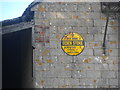
6
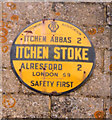
Old circular AA Sign on Manor Farm, Itchen Stoke
Old AA Sign set on the side of a barn on Manor Farm, Itchen Stoke, 2 miles west of New Alresford. Itchen Stoke and Ovington parish.
This is the Circular, village name on black band, no Motor Union symbol or name type, dating from 1923, showing distances Itchen Abbas 2 Alresford 2 London 59.
There were five series of AA signs, mostly dating from 1923 and made by Francis & Co / Franco in Deptford, London. The village name and distance to London were displayed.
Milestone Society National ID: HA-ITCHEN
Image: © Milestone Society
Taken: Unknown
0.10 miles
7
Old AA sign on lichen-spotted wall, Manor Farm, Itchen Stoke
Image: © Bikeboy
Taken: 12 Oct 2013
0.11 miles
8
Manor Farm, Itchen Stoke
See http://www.geograph.org.uk/photo/3703718for a close up of the yellow AA sign on the wall.
Image: © Bikeboy
Taken: 12 Oct 2013
0.11 miles
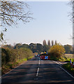
9
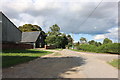
B3047 at Manor Farm, Itchen Stoke
The entrance at right is to Andrew Smith & Son's auction premises http://www.andrewsmithandson.com/ , housed in a large converted barn.
Image: © Peter Facey
Taken: 13 Nov 2011
0.13 miles
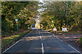
10
B3047 near Manor Farm
Looking towaqrds New Alresford. The narrow single track road at right goes past Itchenstoke Mill. The road works were to repair collapsed telephone ducts.
Image: © Peter Facey
Taken: 13 Nov 2011
0.16 miles