IMAGES TAKEN NEAR TO
Petersfield Road, ALRESFORD, SO24 0NH
Introduction
This page details the photographs taken nearby to Petersfield Road, SO24 0NH by members of the Geograph project.
The Geograph project started in 2005 with the aim of publishing, organising and preserving representative images for every square kilometre of Great Britain, Ireland and the Isle of Man.

There are currently over 7.5m images from over14,400 individuals and you can help contribute to the project by visiting https://www.geograph.org.uk
Image Map
Images are licensed for reuse under creativecommons.org/licenses/by-sa/2.0
Notes
- Clicking on the map will re-center to the selected point.
- The higher the marker number, the further away the image location is from the centre of the postcode.
Image Listing (49 Images Found)
Images are licensed for reuse under creativecommons.org/licenses/by-sa/2.0
Image
Details
Distance
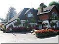
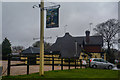
4
Cheriton : The Hinton Arms
A pub seen off of Petersfield Road in Cheriton.
Image: © Lewis Clarke
Taken: 29 Mar 2018
0.04 miles
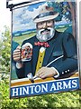
5
Cheriton : The Hinton Arms
The Hinton Arms in Cheriton on Petersfield Road.
Image: © Lewis Clarke
Taken: 29 Mar 2018
0.05 miles
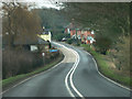
7
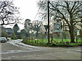
Cheriton : Kilmeston Road
A road off Petersfield Road.
Image: © Lewis Clarke
Taken: 29 Mar 2018
0.05 miles
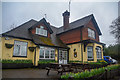
8
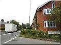
Petersfield Road at the junction of Kilmeston Road
Image: © David Howard
Taken: 24 Jul 2016
0.05 miles
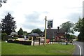
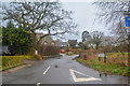
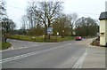
9
A lot of road signs
A crossroads on the A272.
Image: © Robin Webster
Taken: 3 Apr 2014
0.05 miles
10
Itchen Way (206)
The route turns left from the A272 to use Kilmeston Road.
Image: © Shazz
Taken: 8 Apr 2013
0.05 miles