IMAGES TAKEN NEAR TO
Wood Lane, ALRESFORD, SO24 0JW
Introduction
This page details the photographs taken nearby to Wood Lane, SO24 0JW by members of the Geograph project.
The Geograph project started in 2005 with the aim of publishing, organising and preserving representative images for every square kilometre of Great Britain, Ireland and the Isle of Man.

There are currently over 7.5m images from over14,400 individuals and you can help contribute to the project by visiting https://www.geograph.org.uk
Image Map
Images are licensed for reuse under creativecommons.org/licenses/by-sa/2.0
Notes
- Clicking on the map will re-center to the selected point.
- The higher the marker number, the further away the image location is from the centre of the postcode.
Image Listing (38 Images Found)
Images are licensed for reuse under creativecommons.org/licenses/by-sa/2.0
Image
Details
Distance
1
Woodlane Close, Bramdean
Seen from its closed end.
Image: © Peter Facey
Taken: 8 Mar 2009
0.07 miles
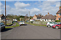
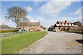
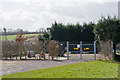
2
Wood Lane, Bramdean
Bramdean and Hinton Ampner Village Hall is off to the left.
Image: © Robin Webster
Taken: 27 Mar 2007
0.09 miles
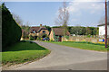
3
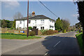
Jordan House, Wood Lane, Bramdean
The planning 'Village Design Statement for the parishes of Bramdean and Hinton Ampner' mentions this as one of the houses 'once used for commercial purposes'. Indeed the side facing the road has lower windows and surrounds looking like a shop frontage.
Image: © Robin Webster
Taken: 27 Mar 2007
0.09 miles
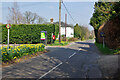
4
Approaching Woodlane Close on footpath
The property on the right is number 12. With Jubilee recreation ground on the left.
Image: © Peter Facey
Taken: 8 Mar 2009
0.11 miles
5
The Spinney, Bramdean
A 1990s insertion of five houses in the old village structure.
Image: © Robin Webster
Taken: 27 Mar 2007
0.11 miles
6
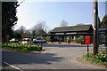
Bramdean and Hinton Ampner Village Hall
The left hand end appears to house a playgroup.
Image: © Robin Webster
Taken: 27 Mar 2007
0.12 miles
7
Jubilee Recreation Ground, Bramdean
The Jubilee 1977 2002 (significance of these dates is unclear) Recreation Ground is maintained by Bramdean & Hinton Ampner Parish Council.
Image: © Peter Facey
Taken: 8 Mar 2009
0.12 miles
8
Sewage plant south of Woodlane Close
A small plant typical of those maintained by Winchester City Council. The footpath to the A272 is glimpsed at right.
Image: © Peter Facey
Taken: 8 Mar 2009
0.14 miles
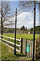
9

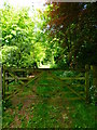
Gate on footpath north of Bramdean
The path turns left here as seen on the sign, and not ahead as mapped.
Image: © Shazz
Taken: 16 May 2014
0.17 miles