IMAGES TAKEN NEAR TO
Petersfield Road, ALRESFORD, SO24 0EQ
Introduction
This page details the photographs taken nearby to Petersfield Road, SO24 0EQ by members of the Geograph project.
The Geograph project started in 2005 with the aim of publishing, organising and preserving representative images for every square kilometre of Great Britain, Ireland and the Isle of Man.

There are currently over 7.5m images from over14,400 individuals and you can help contribute to the project by visiting https://www.geograph.org.uk
Image Map
Images are licensed for reuse under creativecommons.org/licenses/by-sa/2.0
Notes
- Clicking on the map will re-center to the selected point.
- The higher the marker number, the further away the image location is from the centre of the postcode.
Image Listing (7 Images Found)
Images are licensed for reuse under creativecommons.org/licenses/by-sa/2.0
Image
Details
Distance
3
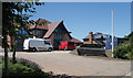
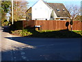
New Houses, Park Lane
A small development of spacious looking new properties nearing completion on the edge of Ropley.
Image: © Des Blenkinsopp
Taken: 7 Jul 2023
0.14 miles
4
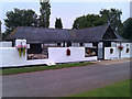
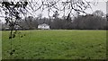
Hampshire Hunt - Foxhound Kennels
The foxhounds at the Hampshire Hunt, Ropley, Hampshire.
Image: © HackBitz
Taken: 5 Sep 2010
0.19 miles
5
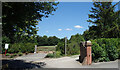
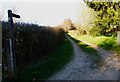
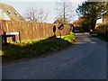
Gate on a bend
Three entrances side by side on a bend in Park Lane. The middle one is a public footpath.
Image: © Des Blenkinsopp
Taken: 7 Jul 2023
0.20 miles