IMAGES TAKEN NEAR TO
Wharf Mews, WINCHESTER, SO23 9WW
Introduction
This page details the photographs taken nearby to Wharf Mews, SO23 9WW by members of the Geograph project.
The Geograph project started in 2005 with the aim of publishing, organising and preserving representative images for every square kilometre of Great Britain, Ireland and the Isle of Man.

There are currently over 7.5m images from over14,400 individuals and you can help contribute to the project by visiting https://www.geograph.org.uk
Image Map (Loading...)


Getting Data...Please wait
Leaflet Map data © OpenStreetMap
Images are licensed for reuse under creativecommons.org/licenses/by-sa/2.0
Notes
- Clicking on the map will re-center to the selected point.
- The higher the marker number, the further away the image location is from the centre of the postcode.
Image Listing (279 Images Found)
Images are licensed for reuse under creativecommons.org/licenses/by-sa/2.0
Image
Details
Distance
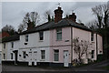
1
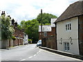
Domum Road, Winchester
Seen from the bottom of Wharf Hill.
Image: © Peter Trimming
Taken: 21 May 2009
0.02 miles
2
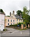
Wharf House, Wharf Hill, Winchester
Domum Road is ahead to the right of the three pillars.
Image: © Peter Facey
Taken: 11 Jul 2008
0.02 miles
3
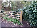
Footpath from Domum Road to the water meadows in Winchester
Image: © Shazz
Taken: 3 Dec 2011
0.02 miles
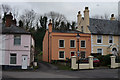
4
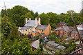
Housing on Wharf Hill
The road in foreground is to Madely's Yard (commercial units off picture right). The newly refurbished house appears to be number 31 Wharf Hill.
Image: © Peter Facey
Taken: 23 May 2015
0.02 miles
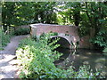
5
Winchester, Wharf Bridge
Footbridge over Itchen Navigation; judging from ruts, the bridge might once have served wheeled vehicles.
Image: © Mike Faherty
Taken: 24 Jul 2013
0.02 miles
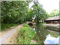
6
Wharf Bridge, Winchester
Officially the head of navigation, (although a few boats worked a short distance further upstream to serve Wharf Mill), this bridge, built in the 1760s, is the oldest surviving bridge over the River Itchen. The public right of navigation on the Itchen has never been statutorily extinguished.
Image: © Dr Neil Clifton
Taken: 4 Jun 2009
0.03 miles
7
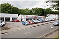
Citro?n garage in Bar End road, Winchester
Seen from atop some access steps to a house on the opposite side of the road.
Image: © Peter Facey
Taken: 11 Jul 2008
0.03 miles
8
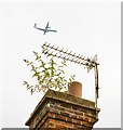
High flying Buddleja on number 27 Beaconsfield Terrace, Winchester
This area of Winchester is also below the flight path to Southampton International Airport and planes fly over every few minutes during the day.
Image: © Peter Facey
Taken: 11 Jul 2008
0.03 miles
9
Wharf Hill, Winchester
The lower part of the road, close to the river.
Image: © Peter Trimming
Taken: 10 Dec 2015
0.03 miles
10
Wharf Hill, Winchester
The lower part of the road, close to the river.
Image: © Peter Trimming
Taken: 10 Dec 2015
0.03 miles