IMAGES TAKEN NEAR TO
St. Cross Road, WINCHESTER, SO23 9RX
Introduction
This page details the photographs taken nearby to St. Cross Road, SO23 9RX by members of the Geograph project.
The Geograph project started in 2005 with the aim of publishing, organising and preserving representative images for every square kilometre of Great Britain, Ireland and the Isle of Man.

There are currently over 7.5m images from over14,400 individuals and you can help contribute to the project by visiting https://www.geograph.org.uk
Image Map
Images are licensed for reuse under creativecommons.org/licenses/by-sa/2.0
Notes
- Clicking on the map will re-center to the selected point.
- The higher the marker number, the further away the image location is from the centre of the postcode.
Image Listing (43 Images Found)
Images are licensed for reuse under creativecommons.org/licenses/by-sa/2.0
Image
Details
Distance

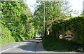
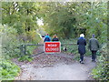
3
Five Bridges Road
Just after the white railings are footpaths to right and left.
Image: © Shazz
Taken: 3 Dec 2011
0.09 miles
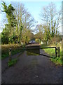
5
Footpath with stile leads off Five Bridges Road
Image: © Shazz
Taken: 3 Dec 2011
0.11 miles
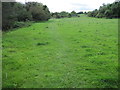
7
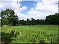
St Cross, cattle grazing
Next to St Cross Farm.
Image: © Mike Faherty
Taken: 24 Jul 2013
0.12 miles

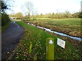
9
St Cross, Five Bridges Road
Formerly A333, now bridleway across water meadows and River Itchen.
Image: © Mike Faherty
Taken: 24 Jul 2013
0.12 miles
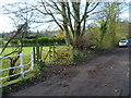
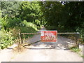
10
Old road now closed, used as a footpath
Image: © Rob Purvis
Taken: 28 Oct 2018
0.13 miles