IMAGES TAKEN NEAR TO
Domum Road, WINCHESTER, SO23 9NN
Introduction
This page details the photographs taken nearby to Domum Road, SO23 9NN by members of the Geograph project.
The Geograph project started in 2005 with the aim of publishing, organising and preserving representative images for every square kilometre of Great Britain, Ireland and the Isle of Man.

There are currently over 7.5m images from over14,400 individuals and you can help contribute to the project by visiting https://www.geograph.org.uk
Image Map (Loading...)


Getting Data...Please wait
Leaflet Map data © OpenStreetMap
Images are licensed for reuse under creativecommons.org/licenses/by-sa/2.0
Notes
- Clicking on the map will re-center to the selected point.
- The higher the marker number, the further away the image location is from the centre of the postcode.
Image Listing (174 Images Found)
Images are licensed for reuse under creativecommons.org/licenses/by-sa/2.0
Image
Details
Distance
1
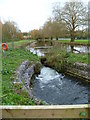
The Itchen Navigation looking towards Winchester
In the foreground is a sluice. Another one is at Image Across the water are playing fields.
Image: © Shazz
Taken: 3 Dec 2011
0.01 miles
2
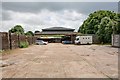
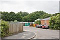
Premises in Bar End Industrial Estate
Seen from footpath between Domum Road and Barfield Close. The use of the premises was unclear.
Image: © Peter Facey
Taken: 11 Jul 2008
0.02 miles
3
Public footpath, east bank, Itchen Navigation
Part of the Itchen Way. The navigation is being dewatered over two days, to allow dredging [for flood prevention, not navigation].
Image: © Christine Johnstone
Taken: 4 Jul 2015
0.02 miles
4
Access road off Barfield Close
Green coloured buildings are occupied by Dairy Crest.
Image: © Peter Facey
Taken: 11 Jul 2008
0.02 miles
5
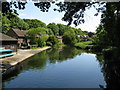
Winchester College Boat Club
Photographed from Wharf Bridge. Whether this is the site of a former wharf is not known to me, but appears likely. This is privately owned, and the public launching of boats here is not allowed.
Image: © Dr Neil Clifton
Taken: 4 Jun 2009
0.02 miles
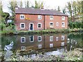
7
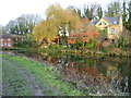
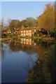
Cottages reflected in the Itchen Navigation, Winchester
Looking north from the path alongside the Itchen Navigation, a short distance south of Wharf Bridge. Compare and contrast with this more wintery view: Image
Image: © Jim Champion
Taken: 30 Aug 2005
0.03 miles
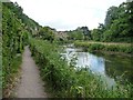
8
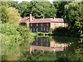
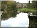
Cottages next to the Itchen Navigation
This shallow clear waterway is the Itchen Navigation, just to the south of Winchester city centre. The cottages are on Domum Road, which leads to Wharf Hill. Compare and contrast with this more summery view: Image
Image: © Jim Champion
Taken: 16 Dec 2007
0.03 miles
9
The Itchen Navigation seen from Winchester footbridge
Image: © Shazz
Taken: 3 Dec 2011
0.04 miles