IMAGES TAKEN NEAR TO
Peninsula Square, WINCHESTER, SO23 8GJ
Introduction
This page details the photographs taken nearby to Peninsula Square, SO23 8GJ by members of the Geograph project.
The Geograph project started in 2005 with the aim of publishing, organising and preserving representative images for every square kilometre of Great Britain, Ireland and the Isle of Man.

There are currently over 7.5m images from over14,400 individuals and you can help contribute to the project by visiting https://www.geograph.org.uk
Image Map
Images are licensed for reuse under creativecommons.org/licenses/by-sa/2.0
Notes
- Clicking on the map will re-center to the selected point.
- The higher the marker number, the further away the image location is from the centre of the postcode.
Image Listing (801 Images Found)
Images are licensed for reuse under creativecommons.org/licenses/by-sa/2.0
Image
Details
Distance
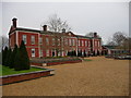
1
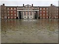
Peninsula Barracks
On this site, William the Conqueror built Winchester Castle which was extended by King Henry III. In 1645, during the Civil War, the Castle was besieged by Oliver Cromwell and, after the Royalists had surrendered, the castle was largely demolished in 1651. In 1683, King Charles II chose the site for a palace overlooking Winchester Cathedral. It was designed in the manner of Versailles by Sir Christopher Wren but, following the death of King Charles II, it was never completed.
Opposite here is the King's House which was the main building of the palace. During the 18th century, it was used to house French, Spanish and Dutch prisoners-of-war. In 1796, the site was leased from the Crown as the site for a military barracks. In 1894, the King's House was destroyed by fire and was then rebuilt in a slightly different position but in a similar style to Wren's original design.
From 1856 to 1986 the barracks were used as a recruits' training depot and the area in front was a parade ground. In 1943 - 44 the barracks housed American troops preparing to take part in the D-Day landings. In 1994, the Ministry of Defence relinquished its occupation of most of the site for residential use and the area in the centre was landscaped and named Peninsla Square - see peninsulasquare.org.uk/home/
Image: © Marathon
Taken: 19 Feb 2024
0.01 miles
2

'Mayflower'
No.61306 'Mayflower' with 'The Steam Dreams' excursion from Southend to Eastleigh.
Image: © Peter Trimming
Taken: 18 Jul 2019
0.03 miles
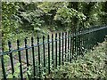
4
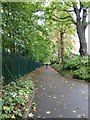
Path between peninsula Barracks and the railway line
Image: © Basher Eyre
Taken: 2 Oct 2010
0.03 miles
6
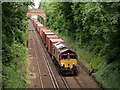
Winchester
Class 66 locomotive seen approaching the St.James' Lane bridge.
Image: © Peter Trimming
Taken: 18 Jul 2019
0.03 miles
7
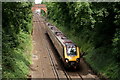
Winchester
Cross-country train seen approaching the St.James' Lane bridge.
Image: © Peter Trimming
Taken: 18 Jul 2019
0.03 miles
8
Winchester - County Court
Hampshires county court buildings.
Image: © Chris Talbot
Taken: 14 Dec 2010
0.03 miles
9
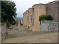
Winchester - County Court Steps
The steep flight of steps that lead down to Winchester County Court buildings from the council offices,
Image: © Chris Talbot
Taken: 14 Dec 2010
0.03 miles
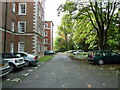
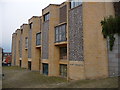
10
Winchester - Peninsula Barracks
This area of former barracks on Romsey Road has been converted into housing and also houses several museums.
Image: © Chris Talbot
Taken: 14 Dec 2010
0.03 miles