IMAGES TAKEN NEAR TO
Lawn Street, WINCHESTER, SO23 8DS
Introduction
This page details the photographs taken nearby to Lawn Street, SO23 8DS by members of the Geograph project.
The Geograph project started in 2005 with the aim of publishing, organising and preserving representative images for every square kilometre of Great Britain, Ireland and the Isle of Man.

There are currently over 7.5m images from over14,400 individuals and you can help contribute to the project by visiting https://www.geograph.org.uk
Image Map (Loading...)


Getting Data...Please wait
Leaflet Map data © OpenStreetMap
Images are licensed for reuse under creativecommons.org/licenses/by-sa/2.0
Notes
- Clicking on the map will re-center to the selected point.
- The higher the marker number, the further away the image location is from the centre of the postcode.
Image Listing (987 Images Found)
Images are licensed for reuse under creativecommons.org/licenses/by-sa/2.0
Image
Details
Distance
2
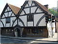
Winchester's "Oldest" House
on Union Street, Winchester.
Image: © David Seale
Taken: 21 Apr 2007
0.02 miles
7

The City of Winchester Fire Station
Sold! The Fire Station is scheduled to be closed in March 2011, when the service moves to a new location. The current location is at the junction of North Walls and Eastgate Street.
Image: © Peter Trimming
Taken: 4 Mar 2010
0.04 miles
9
Durngate Terrace, Winchester
A terrace between two channels of the Itchen.
Image: © Pierre Terre
Taken: 2 Oct 2008
0.04 miles