IMAGES TAKEN NEAR TO
Kings Close, WINCHESTER, SO23 7TE
Introduction
This page details the photographs taken nearby to Kings Close, SO23 7TE by members of the Geograph project.
The Geograph project started in 2005 with the aim of publishing, organising and preserving representative images for every square kilometre of Great Britain, Ireland and the Isle of Man.

There are currently over 7.5m images from over14,400 individuals and you can help contribute to the project by visiting https://www.geograph.org.uk
Image Map
Images are licensed for reuse under creativecommons.org/licenses/by-sa/2.0
Notes
- Clicking on the map will re-center to the selected point.
- The higher the marker number, the further away the image location is from the centre of the postcode.
Image Listing (23 Images Found)
Images are licensed for reuse under creativecommons.org/licenses/by-sa/2.0
Image
Details
Distance
1
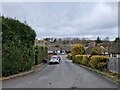
Springvale Road, Kings Worthy
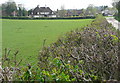
Road works at the junction of Springvale Road (on the left) and Lovedon Road, which becomes Stoke Charity Road beyond the junction. This is the end of suburbia in this large village north of Winchester. On the right is open countryside.
Image: © Peter Jordan
Taken: 4 Dec 2005
0.04 miles
2
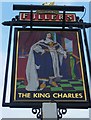
Sign at "The King Charles" PH at Kings Worthy
Image: © Shazz
Taken: 27 Mar 2013
0.05 miles
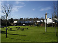
3
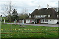
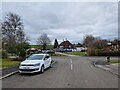
The King Charles
An attractive pub at the boundary between a large housing area, Springvale, to the right and open countryside to the left. This effectively marks the northern boundary of the Winchester urban area, and as the bus terminates here it is a good stepping off point for a country walk.
Image: © Graham Horn
Taken: 11 Apr 2011
0.05 miles
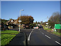
4
Towards Springvale
Approaching from the north, this is the end of the footpath and the start of the Winchester urban area at Springvale. But there is a welcoming pub here, The King Charles, whilst waiting for the bus in to the city.
Image: © Graham Horn
Taken: 11 Apr 2011
0.05 miles
5
Looking from Vale Way across to The King Charles
The road in between is Springvale Road.
Image: © Basher Eyre
Taken: 17 Feb 2023
0.05 miles
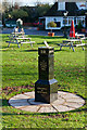
7
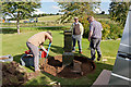
Queen's Diamond Jubilee memorial, Kings Worthy
On the corner of Springvale Road and Lovedon Lane, opposite the King Charles pub. The memorial had been installed a few weeks prior to photographing, but vandals had already stolen the brass sundial on its top. These people were digging a circular bed for a stone plinth. Later http://www.geograph.org.uk/photo/3228760
Image: © Peter Facey
Taken: 27 Sep 2012
0.06 miles
8
Queen's Diamond Jubilee memorial, Kings Worthy
With completed stone plinth, and replaced sundial. Earlier http://www.geograph.org.uk/photo/3165023
Image: © Peter Facey
Taken: 11 Nov 2012
0.06 miles
9
Kings Worthy - King Charles pub's outside seating and Vale Way
Looking west from Lovedon Lane, King's Worthy, across the outside seating area for the King Charles pub (pub is out of view to the left). The road is Springvale Road with the houses situated on Vale Way,
Image: © Peter Jordan
Taken: 4 Dec 2005
0.08 miles