IMAGES TAKEN NEAR TO
Haydn Close, WINCHESTER, SO23 7RD
Introduction
This page details the photographs taken nearby to Haydn Close, SO23 7RD by members of the Geograph project.
The Geograph project started in 2005 with the aim of publishing, organising and preserving representative images for every square kilometre of Great Britain, Ireland and the Isle of Man.

There are currently over 7.5m images from over14,400 individuals and you can help contribute to the project by visiting https://www.geograph.org.uk
Image Map (Loading...)


Getting Data...Please wait
Leaflet Map data © OpenStreetMap
Images are licensed for reuse under creativecommons.org/licenses/by-sa/2.0
Notes
- Clicking on the map will re-center to the selected point.
- The higher the marker number, the further away the image location is from the centre of the postcode.
Image Listing (38 Images Found)
Images are licensed for reuse under creativecommons.org/licenses/by-sa/2.0
Image
Details
Distance
2
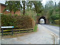
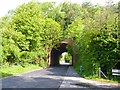
Railway Bridge over Springvale Road
This brick arched bridge used to carry the railway line from Alton to Winchester. The line had originally opened in 1865, but was closed down in 1973. It now carries a public footpath along the old trackbed.
Image: © mike smith
Taken: 25 May 2013
0.06 miles
3
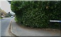
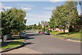
Looking along Springvale Road from Haydn Close
Image: © Shazz
Taken: 27 Mar 2013
0.06 miles
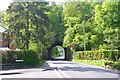
4
Kings Worthy - disused railway bridge
This heavily wooded railway bridge is now redundant, but used to carry the Mid Hants Railway between Winchester and Alton. The road is Springvale Road in Kings Worthy.
Image: © Peter Jordan
Taken: 11 Sep 2005
0.08 miles
5
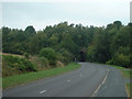
Railway Bridge over Springvale Road
This brick arched bridge used to carry the railway line from Alton to Winchester. The line had originally opened in 1865, but was closed down in 1973. It now carries a public footpath along the old trackbed.
Image: © mike smith
Taken: 25 May 2013
0.08 miles
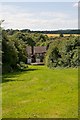
6
Pound Road, Kingsworthy
This, together with Ramsay Road, affords access to the centre of this community.
Image: © Peter Facey
Taken: 2 Aug 2008
0.11 miles
7
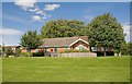
Lionel Tubbs Hall & Kingswirthy Community Centre
A plaque reads "Donated and constructed by Clarke Quality Homes 1996".
Image: © Peter Facey
Taken: 2 Aug 2008
0.12 miles
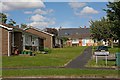
8
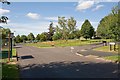
Green off Pound Road, Kingsworthy
The green contains a wild flower area and is adjacent to a children's play area and the Community Centre.
Image: © Peter Facey
Taken: 2 Aug 2008
0.12 miles
10
Broadview Recreation Ground, looking at Wesley Road
Image: © Peter Facey
Taken: 2 Aug 2008
0.13 miles