IMAGES TAKEN NEAR TO
Elizabeth Close, WINCHESTER, SO23 7PE
Introduction
This page details the photographs taken nearby to Elizabeth Close, SO23 7PE by members of the Geograph project.
The Geograph project started in 2005 with the aim of publishing, organising and preserving representative images for every square kilometre of Great Britain, Ireland and the Isle of Man.

There are currently over 7.5m images from over14,400 individuals and you can help contribute to the project by visiting https://www.geograph.org.uk
Image Map
Images are licensed for reuse under creativecommons.org/licenses/by-sa/2.0
Notes
- Clicking on the map will re-center to the selected point.
- The higher the marker number, the further away the image location is from the centre of the postcode.
Image Listing (28 Images Found)
Images are licensed for reuse under creativecommons.org/licenses/by-sa/2.0
Image
Details
Distance
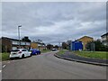
1
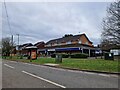
Wandering westwards along the Bashire (41)
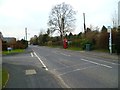
Bus stop outside Tesco Express, King's Worthy
Image: © Basher Eyre
Taken: 17 Feb 2023
0.08 miles
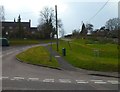
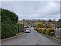
3
Junction of Somerville Road and North Road, Kings Worthy
Image: © David Martin
Taken: 2 May 2016
0.11 miles
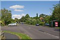
5
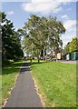
Cyclepath running behind flats on Fraser Road
Image: © Peter Facey
Taken: 2 Aug 2008
0.12 miles
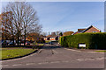
7
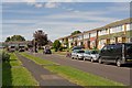
Fraser Road, Kingsworthy
There are a lot of flats along this road.
Image: © Peter Facey
Taken: 2 Aug 2008
0.14 miles
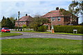
9
Forbes Road, Kingsworthy
Looking up the hill towards Fraser Road.
Image: © Peter Facey
Taken: 2 Aug 2008
0.16 miles