IMAGES TAKEN NEAR TO
Kings Worthy, WINCHESTER, SO23 7LB
Introduction
This page details the photographs taken nearby to SO23 7LB by members of the Geograph project.
The Geograph project started in 2005 with the aim of publishing, organising and preserving representative images for every square kilometre of Great Britain, Ireland and the Isle of Man.

There are currently over 7.5m images from over14,400 individuals and you can help contribute to the project by visiting https://www.geograph.org.uk
Image Map
Images are licensed for reuse under creativecommons.org/licenses/by-sa/2.0
Notes
- Clicking on the map will re-center to the selected point.
- The higher the marker number, the further away the image location is from the centre of the postcode.
Image Listing (17 Images Found)
Images are licensed for reuse under creativecommons.org/licenses/by-sa/2.0
Image
Details
Distance
1
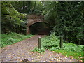
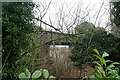
Bridge over disused Didcot Railway
Bridge over disused railway from Winchester to Didcot
This heavily wooded railway track is now redundant, but used to carry goods from the Midlands to Southampton. The track is now used as a footpath from Kings Worthy to South Wonston.
Image: © Jim Probert
Taken: 28 Oct 2006
0.03 miles
2
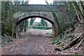
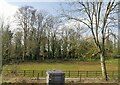
Former railway line
The trackbed of the former Didcot, Newbury, Southampton railway line, closed in 1963. The bridge was the old route to Woodhams Farm, but access is now just in front of the hedge. Beyond the hedge the former railway goes underneath the existing London to Southampton railway line, which can just be seen.
Image: © Graham Horn
Taken: 14 Feb 2010
0.05 miles
3
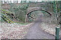
Former railway line near Woodhams Farm
This is the trackbed of the former Didcot, Newbury, Southampton railway line, the Great Western rival to the London and South Western route to the important port of Southampton. This is looking north. The line closed in 1963. Although this section is not officially a public right of way, many locals gain access here for walks.
Image: © Graham Horn
Taken: 14 Feb 2010
0.07 miles
4
Railway Bridge near Woodhams Farm
This traditional brick railway bridge carries the main London to Southampton line. It is over a small lane that leads to Woodhams Farm.
Image: © mike smith
Taken: 25 May 2013
0.07 miles
5
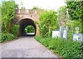
Former railway line
The former Didcot, Newbury, Southampton route went underneath the older London and South Western route at this bridge. The older route survives, whilst the DNS route beyond this bridge has been filled in and ploughed over.
Image: © Graham Horn
Taken: 14 Feb 2010
0.07 miles
7
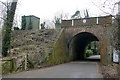
Woodhams Farm railway bridge
This is the lane leading to Woodhams Farm, which goes under a bridge on the Southampton to London main railway line, constructed in 1840.
Image: © Graham Horn
Taken: 14 Feb 2010
0.08 miles
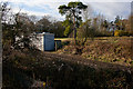
8
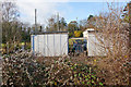
Railway electricity substation at Woodhams Farm
At a site formerly the junction of three railway lines, two of which have been dismantled. A transformer can be seen between the two sheds. This is presumably a substation taking 33 KV from cables running beside the railway line, transforming it down to 750 V, rectifying it, and applying it to the third rail.
Beyond can be seen three mobile phone masts.
Image: © Peter Facey
Taken: 25 Nov 2012
0.12 miles
9
Railway electricity substation at Woodhams Farm
At a site formerly the junction of three railway lines, two of which have been dismantled. Beyond can be seen three mobile phone masts.
Image: © Peter Facey
Taken: 25 Nov 2012
0.12 miles
10
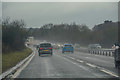
City of Winchester : Winchester Bypass A34
Heading along the Winchester Bypass on the A34.
Image: © Lewis Clarke
Taken: 29 Mar 2018
0.17 miles