IMAGES TAKEN NEAR TO
Burnet Lane, WINCHESTER, SO23 7GN
Introduction
This page details the photographs taken nearby to Burnet Lane, SO23 7GN by members of the Geograph project.
The Geograph project started in 2005 with the aim of publishing, organising and preserving representative images for every square kilometre of Great Britain, Ireland and the Isle of Man.

There are currently over 7.5m images from over14,400 individuals and you can help contribute to the project by visiting https://www.geograph.org.uk
Image Map (Loading...)


Getting Data...Please wait
Leaflet Map data © OpenStreetMap
Images are licensed for reuse under creativecommons.org/licenses/by-sa/2.0
Notes
- Clicking on the map will re-center to the selected point.
- The higher the marker number, the further away the image location is from the centre of the postcode.
Image Listing (25 Images Found)
Images are licensed for reuse under creativecommons.org/licenses/by-sa/2.0
Image
Details
Distance
1
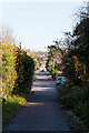
Looking along Hookpit Farm Lane
The cars are at the southwestern end of this lane, whilst in the foreground is a byway. At time of photographing, a planning application was being considered to build 25 affordable homes on the triangular rough land to the right of this byway.
Image: © Peter Facey
Taken: 18 Nov 2012
0.10 miles
2
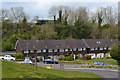
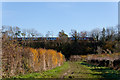
Freight train on embankment above houses at Springvale
Image: © David Martin
Taken: 2 May 2016
0.11 miles
4
Firs Close and Hookpit Farm Lane
A triangular green, with housing on Firs Close (left of the red car) and Hookpit Farm Lane (ahead on right).
Image: © Peter Facey
Taken: 18 Nov 2012
0.12 miles
5
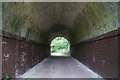
Lot of work for a byway
Passing under the mainline between London and the south coast.
Image: © Fernweh
Taken: 24 Aug 2014
0.13 miles
6
Byway and railway line west of Hookpit Farm Lane
Image: © Peter Facey
Taken: 18 Nov 2012
0.14 miles
7
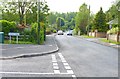
Junction of Forbes Road and Springvale Road
Springvale Road had just been resurfaced when the photo was taken. It is a busy link road in the area.
Image: © mike smith
Taken: 25 May 2013
0.14 miles
8
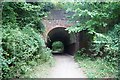
Byway under the main line
The railway above is the main line between London and Southampton. The bridge/tunnel is just a short distance north of Winchester station
Image: © Fernweh
Taken: 24 Aug 2014
0.15 miles
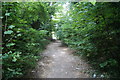
9

Footpath on Old Railway Line
This was once a railway line from Alton to Winchester. The line had originally opened in 1865, but was closed down in 1973. It is now a public footpath along the old trackbed.
Image: © mike smith
Taken: 25 May 2013
0.16 miles
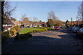
10
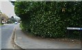
Looking along Springvale Road from Haydn Close
Image: © Shazz
Taken: 27 Mar 2013
0.16 miles