IMAGES TAKEN NEAR TO
Ramsay Road, WINCHESTER, SO23 7FE
Introduction
This page details the photographs taken nearby to Ramsay Road, SO23 7FE by members of the Geograph project.
The Geograph project started in 2005 with the aim of publishing, organising and preserving representative images for every square kilometre of Great Britain, Ireland and the Isle of Man.

There are currently over 7.5m images from over14,400 individuals and you can help contribute to the project by visiting https://www.geograph.org.uk
Image Map
Images are licensed for reuse under creativecommons.org/licenses/by-sa/2.0
Notes
- Clicking on the map will re-center to the selected point.
- The higher the marker number, the further away the image location is from the centre of the postcode.
Image Listing (44 Images Found)
Images are licensed for reuse under creativecommons.org/licenses/by-sa/2.0
Image
Details
Distance
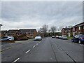
1
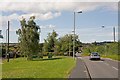
Lovedean Lane, Kingsworthy
Turning on the left is Ramsay Road.
Image: © Peter Facey
Taken: 2 Aug 2008
0.04 miles
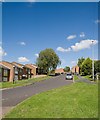
2
Wandering westwards along the Bashire (40)
Looking from Mountbatten Place into Sherwood Close
Image: © Basher Eyre
Taken: 17 Feb 2023
0.06 miles
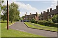
3
Ramsay Road, Kingsworthy
Looking down the hill with Tovey Place on the left. Ramsay Road is a principal access road for this part of Kingsworthy.
Image: © Peter Facey
Taken: 2 Aug 2008
0.07 miles
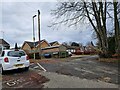
4
Springvale Surgery, Kingsworthy
Considering the amount of housing around here, this is not very big.
Image: © Peter Facey
Taken: 2 Aug 2008
0.07 miles
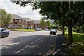
6
Ramsay Road, Kingsworthy
Looking up the hill. Wesley Road is behind camera.
Image: © Peter Facey
Taken: 2 Aug 2008
0.08 miles
7
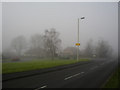
Kings Worthy in the fog
Junction of Lovedon Lane (in the foreground), with Ramsay Road joining from the right. Looking north west. Kings Worthy is a large village north of Winchester. Lovedon Lane forms the eastern boundary of the village.
Image: © Peter Jordan
Taken: 11 Dec 2005
0.08 miles
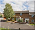
8
Vian Place, Kingsworthy
A cul de sac off Ramsay Road.
Image: © Peter Facey
Taken: 2 Aug 2008
0.08 miles
9
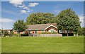
Lionel Tubbs Hall & Kingswirthy Community Centre
A plaque reads "Donated and constructed by Clarke Quality Homes 1996".
Image: © Peter Facey
Taken: 2 Aug 2008
0.08 miles
10
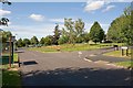
Green off Pound Road, Kingsworthy
The green contains a wild flower area and is adjacent to a children's play area and the Community Centre.
Image: © Peter Facey
Taken: 2 Aug 2008
0.08 miles