IMAGES TAKEN NEAR TO
St. Giles Hill, WINCHESTER, SO23 0HH
Introduction
This page details the photographs taken nearby to St. Giles Hill, SO23 0HH by members of the Geograph project.
The Geograph project started in 2005 with the aim of publishing, organising and preserving representative images for every square kilometre of Great Britain, Ireland and the Isle of Man.

There are currently over 7.5m images from over14,400 individuals and you can help contribute to the project by visiting https://www.geograph.org.uk
Image Map
Images are licensed for reuse under creativecommons.org/licenses/by-sa/2.0
Notes
- Clicking on the map will re-center to the selected point.
- The higher the marker number, the further away the image location is from the centre of the postcode.
Image Listing (548 Images Found)
Images are licensed for reuse under creativecommons.org/licenses/by-sa/2.0
Image
Details
Distance
1

Edward VII postbox, Alresford Road / St. John's Road, SO23
Image: © Mike Quinn
Taken: 14 Nov 2012
0.05 miles
2

Edward VII postbox, Alresford Road / St. John's Road, SO23 - royal cipher
See Image
Image: © Mike Quinn
Taken: 14 Nov 2012
0.05 miles
3

Alresford Road / St. John's Road, SO23 (2)
Shows the location of Image
Image: © Mike Quinn
Taken: 14 Nov 2012
0.05 miles
4
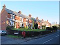
Alresford Road / St. John's Road, SO23
Shows the location of Image
Image: © Mike Quinn
Taken: 14 Nov 2012
0.06 miles
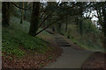
6
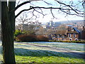
St John's Hill
Small hillside park with stunning view over Winchester city centre from the north-east. St John's Church and Winchester cathedral towers are easily visible. Midwinter frost is lifting as the low angled sunrays warm the ground.
Image: © Colin Smith
Taken: 7 Dec 2008
0.07 miles
7
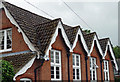
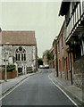
Detail of St John's Hall, St John's Street, Winchester
Decorative bargeboards (originally a school built in 1856-57).
Did the architect, John Colson, have a finger in this pie too: Image]?
Image: © Stephen Richards
Taken: 13 Jul 2012
0.07 miles
8
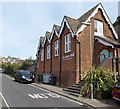
St John's Hall, Winchester
On the east side of St John's Street, near St John the Baptist church. http://www.geograph.org.uk/photo/4189416
Some smaller white letters are missing from the row below the hall's name. It was difficult to deduce what the row originally was because the text did not look to be English. A nearby notice provided the answer - Casa dei Bambini, Italian for Children's House. Casa dei Bambini is a Montessori Day Nursery.
Image: © Jaggery
Taken: 28 Sep 2014
0.08 miles
9
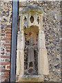
The Parish Church of St. John The Baptist, St. John's Street, SO23 - statue niche
See Image
Image: © Mike Quinn
Taken: 14 Nov 2012
0.08 miles