IMAGES TAKEN NEAR TO
Alresford Road, WINCHESTER, SO23 0HG
Introduction
This page details the photographs taken nearby to Alresford Road, SO23 0HG by members of the Geograph project.
The Geograph project started in 2005 with the aim of publishing, organising and preserving representative images for every square kilometre of Great Britain, Ireland and the Isle of Man.

There are currently over 7.5m images from over14,400 individuals and you can help contribute to the project by visiting https://www.geograph.org.uk
Image Map
Images are licensed for reuse under creativecommons.org/licenses/by-sa/2.0
Notes
- Clicking on the map will re-center to the selected point.
- The higher the marker number, the further away the image location is from the centre of the postcode.
Image Listing (373 Images Found)
Images are licensed for reuse under creativecommons.org/licenses/by-sa/2.0
Image
Details
Distance
1
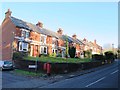
Alresford Road / St. John's Road, SO23
Shows the location of Image
Image: © Mike Quinn
Taken: 14 Nov 2012
0.00 miles
2

Edward VII postbox, Alresford Road / St. John's Road, SO23
Image: © Mike Quinn
Taken: 14 Nov 2012
0.01 miles
3

Edward VII postbox, Alresford Road / St. John's Road, SO23 - royal cipher
See Image
Image: © Mike Quinn
Taken: 14 Nov 2012
0.01 miles
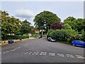
4

Alresford Road / St. John's Road, SO23 (2)
Shows the location of Image
Image: © Mike Quinn
Taken: 14 Nov 2012
0.02 miles
5
Upper section of Blue Ball Hill, above St John's Street, in Winchester
The upper section of Blue Ball Hill, above St John's Street, in Winchester. Joyce Garden can be seen behind the hedge to the right.
Image: © Chris Wood
Taken: 25 Sep 2022
0.09 miles
6
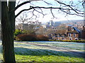
St John's Hill
Small hillside park with stunning view over Winchester city centre from the north-east. St John's Church and Winchester cathedral towers are easily visible. Midwinter frost is lifting as the low angled sunrays warm the ground.
Image: © Colin Smith
Taken: 7 Dec 2008
0.10 miles
7
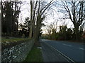
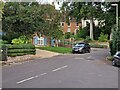
Looking westwards along Alresford Road
(taken from outside St Giles Hill Cemetery)
Image: © Basher Eyre
Taken: 30 Jan 2013
0.10 miles
8
Upper section of Blue Ball Hill, above St John's Street, in Winchester
Image: © Chris Wood
Taken: 25 Sep 2022
0.10 miles
10
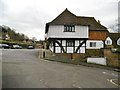
Winchester, Old Blue Ball
Timber-framed house on St. John's Street, dating from C14. Grade II* listed by Historic England: https://historicengland.org.uk/listing/the-list/list-entry/1095386
Image: © Mike Faherty
Taken: 4 Jan 2020
0.11 miles