IMAGES TAKEN NEAR TO
Fiona Close, WINCHESTER, SO23 0HB
Introduction
This page details the photographs taken nearby to Fiona Close, SO23 0HB by members of the Geograph project.
The Geograph project started in 2005 with the aim of publishing, organising and preserving representative images for every square kilometre of Great Britain, Ireland and the Isle of Man.

There are currently over 7.5m images from over14,400 individuals and you can help contribute to the project by visiting https://www.geograph.org.uk
Image Map (Loading...)


Getting Data...Please wait
Leaflet Map data © OpenStreetMap
Images are licensed for reuse under creativecommons.org/licenses/by-sa/2.0
Notes
- Clicking on the map will re-center to the selected point.
- The higher the marker number, the further away the image location is from the centre of the postcode.
Image Listing (112 Images Found)
Images are licensed for reuse under creativecommons.org/licenses/by-sa/2.0
Image
Details
Distance
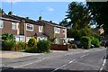
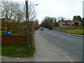
2
Bottom of Winnall Valley Road
A commercial cul de sac. At the bottom of the hill is a play area with a footpath through to Imber Road.
Image: © Peter Facey
Taken: 14 Mar 2012
0.04 miles
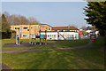
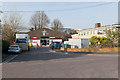
3

Play Area off Firmstone and Moss Roads
In a space formerly occupied by a railway line.
Image: © Peter Facey
Taken: 14 Mar 2012
0.06 miles
4

Car Showroom, Winnall
Looking across Easton Lane from the Itchen Way. Though cut for road traffic at the M3, Easton Lane heads north-east from this point to the village of Easton, where it crosses the Itchen.
Image: © Pierre Terre
Taken: 2 Oct 2008
0.06 miles
5
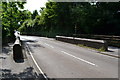
Bridge over disused railway line in Easton Lane
The road crosses a heavily overgrown cutting which was once the route of the Didcot, Newbury and Southampton Railway.
Image: © David Martin
Taken: 28 Aug 2013
0.06 miles
6
The Itchen Way, Winnall
After a short stretch along Wales Street and Easton Lane (with the consolation of three pubs with riverside gardens), the Itchen Way heads back towards the river here, reaching fields in a couple of hundred metres.
Image: © Pierre Terre
Taken: 2 Oct 2008
0.06 miles
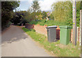
7
Itchen Way (120)
The Way turns left here off Easton Lane.
Image: © Shazz
Taken: 27 Mar 2013
0.06 miles
8

Bottom of Imber Road
Imber Road runs down hill from Winnall Manor Road to here where it becomes (behind camera) Firmstone Road.
Image: © Peter Facey
Taken: 14 Mar 2012
0.07 miles
9

Commercial premises in Winnall Valley Road
The unfortunately named Dicks (electrical Installations) Ltd.
Image: © Peter Facey
Taken: 14 Mar 2012
0.08 miles
10
Commercial Premises in Winnall Valley Road
Moto Rapido, providing Ducati motorbike service.
Image: © Peter Facey
Taken: 14 Mar 2012
0.08 miles