IMAGES TAKEN NEAR TO
Well House Lane, WINCHESTER, SO22 6PG
Introduction
This page details the photographs taken nearby to Well House Lane, SO22 6PG by members of the Geograph project.
The Geograph project started in 2005 with the aim of publishing, organising and preserving representative images for every square kilometre of Great Britain, Ireland and the Isle of Man.

There are currently over 7.5m images from over14,400 individuals and you can help contribute to the project by visiting https://www.geograph.org.uk
Image Map
Images are licensed for reuse under creativecommons.org/licenses/by-sa/2.0
Notes
- Clicking on the map will re-center to the selected point.
- The higher the marker number, the further away the image location is from the centre of the postcode.
Image Listing (5 Images Found)
Images are licensed for reuse under creativecommons.org/licenses/by-sa/2.0
Image
Details
Distance
1
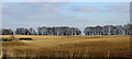
Trees at Well House Farm
A wonderful horizon with bare trees with Well House Farm nestling in a hollow
Image: © john browning
Taken: 19 Jan 2005
0.15 miles
2
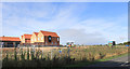
South of Well House Lane
Well House Lane is now on the northern edge of suburban Winchester.
Image: © Des Blenkinsopp
Taken: 24 Aug 2018
0.19 miles
3
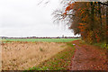
Footpath north of Barton Farm
Running towards the railway line.
Image: © Peter Facey
Taken: 21 Nov 2012
0.20 miles
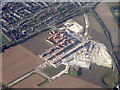
4
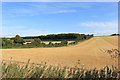
North of Well House Lane
Well House Lane is now the edge of Winchester. North of the lane is farmland, but on the other side is a building site the size of a small town.
Image: © Des Blenkinsopp
Taken: 24 Aug 2018
0.22 miles
5
Housing development
At Harestock, Littleton. Separated from the existing houses by the B3420, on the line of a Roman Road.
Image: © M J Richardson
Taken: 23 Nov 2017
0.24 miles