IMAGES TAKEN NEAR TO
Upton Grey Close, WINCHESTER, SO22 6NE
Introduction
This page details the photographs taken nearby to Upton Grey Close, SO22 6NE by members of the Geograph project.
The Geograph project started in 2005 with the aim of publishing, organising and preserving representative images for every square kilometre of Great Britain, Ireland and the Isle of Man.

There are currently over 7.5m images from over14,400 individuals and you can help contribute to the project by visiting https://www.geograph.org.uk
Image Map
Images are licensed for reuse under creativecommons.org/licenses/by-sa/2.0
Notes
- Clicking on the map will re-center to the selected point.
- The higher the marker number, the further away the image location is from the centre of the postcode.
Image Listing (5 Images Found)
Images are licensed for reuse under creativecommons.org/licenses/by-sa/2.0
Image
Details
Distance

2
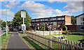
Outside The March Hare
This part of town is called Harestock and the local pub is called The March Hare.
Image: © Des Blenkinsopp
Taken: 21 Aug 2018
0.13 miles
3
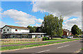
The March Hare
Neighbourhood pub on Priors Dean Road.
Image: © Des Blenkinsopp
Taken: 21 Aug 2018
0.14 miles
5
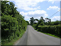
Kennel Road, Littleton, Hampshire
Looking southeast down Kennel Road from Littleton to Harestock.
Image: © Jim Champion
Taken: 11 Jun 2005
0.19 miles