IMAGES TAKEN NEAR TO
Stopher Walk, WINCHESTER, SO22 5ST
Introduction
This page details the photographs taken nearby to Stopher Walk, SO22 5ST by members of the Geograph project.
The Geograph project started in 2005 with the aim of publishing, organising and preserving representative images for every square kilometre of Great Britain, Ireland and the Isle of Man.

There are currently over 7.5m images from over14,400 individuals and you can help contribute to the project by visiting https://www.geograph.org.uk
Image Map
Images are licensed for reuse under creativecommons.org/licenses/by-sa/2.0
Notes
- Clicking on the map will re-center to the selected point.
- The higher the marker number, the further away the image location is from the centre of the postcode.
Image Listing (15 Images Found)
Images are licensed for reuse under creativecommons.org/licenses/by-sa/2.0
Image
Details
Distance
1
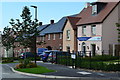
Showhomes at Winchester Village development
Image: © David Martin
Taken: 14 Sep 2016
0.12 miles
2
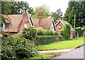
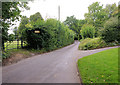
Pitt Manor
Buildings along Kilham Lane.
Image: © Pierre Terre
Taken: 19 Aug 2008
0.15 miles
3
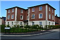
New flats in Swithun Way, Winchester Village development
Image: © David Martin
Taken: 14 Sep 2016
0.15 miles
4
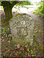
Old Boundary Marker by the B3040, Romsey Road, Winchester Parish
Parish Boundary Marker by the B3040, in parish of Winchester (Winchester District), Romsey Road, 3m back from road at path to gas installation, under tree.
Surveyed
Milestone Society National ID: HA_WIN02pb
Image: © Milestone Society
Taken: Unknown
0.18 miles
5
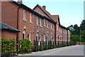
New terrace of houses, Winchester Village development
Image: © David Martin
Taken: 14 Sep 2016
0.18 miles
6
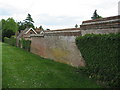
Brick Wall on Kilham Lane
Fine brick wall enclosing substantial premises on Kilham Lane, Winchester - passed by Clarendon Way walkers.
Image: © Chris Heaton
Taken: 10 May 2010
0.19 miles
7
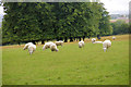
Sheep, Pitt Manor
Viewed from near the top of Kilham Lane. I had a bit of trouble with this one - looking at the horizon, I'm pretty sure the sheep are standing up straight and the field and neatly grazed trees are leaning over, rather than the other way round.
Image: © Pierre Terre
Taken: 19 Aug 2008
0.19 miles
8
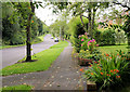
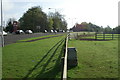
Kilham Lane
Kilham Lane has houses on the east side and the fields and buildings of Pitt Manor on the west side.
Image: © Pierre Terre
Taken: 19 Aug 2008
0.19 miles
9
Kilham Lane
Above Woodfield Drive Kilham Lane loses its separate footway, and the Clarendon Way becomes a game of chicken with rat-runners.
Image: © Pierre Terre
Taken: 19 Aug 2008
0.22 miles
10
Pitt
A typical morning rush hour with traffic tailed back up the Romsey Road from the centre of Winchester to Pitt service station
Image: © Pierre Terre
Taken: 26 Apr 2006
0.22 miles