IMAGES TAKEN NEAR TO
Monarch Way, WINCHESTER, SO22 5PW
Introduction
This page details the photographs taken nearby to Monarch Way, SO22 5PW by members of the Geograph project.
The Geograph project started in 2005 with the aim of publishing, organising and preserving representative images for every square kilometre of Great Britain, Ireland and the Isle of Man.

There are currently over 7.5m images from over14,400 individuals and you can help contribute to the project by visiting https://www.geograph.org.uk
Image Map
Images are licensed for reuse under creativecommons.org/licenses/by-sa/2.0
Notes
- Clicking on the map will re-center to the selected point.
- The higher the marker number, the further away the image location is from the centre of the postcode.
Image Listing (44 Images Found)
Images are licensed for reuse under creativecommons.org/licenses/by-sa/2.0
Image
Details
Distance

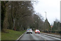
7
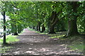
Avenue of trees beside busy road
The B3040 Romsey Road is one of several congested routes into Winchester's city centre - the queueing traffic on the left has been carefully screened by leaves.
Image: © David Martin
Taken: 14 Sep 2016
0.08 miles
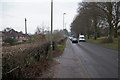
10
B3040 Romsey Road, Winchester
Heading into town.
Image: © Robin Webster
Taken: 17 Mar 2018
0.09 miles