IMAGES TAKEN NEAR TO
Dean Lane, WINCHESTER, SO22 5JR
Introduction
This page details the photographs taken nearby to Dean Lane, SO22 5JR by members of the Geograph project.
The Geograph project started in 2005 with the aim of publishing, organising and preserving representative images for every square kilometre of Great Britain, Ireland and the Isle of Man.

There are currently over 7.5m images from over14,400 individuals and you can help contribute to the project by visiting https://www.geograph.org.uk
Image Map
Images are licensed for reuse under creativecommons.org/licenses/by-sa/2.0
Notes
- Clicking on the map will re-center to the selected point.
- The higher the marker number, the further away the image location is from the centre of the postcode.
Image Listing (10 Images Found)
Images are licensed for reuse under creativecommons.org/licenses/by-sa/2.0
Image
Details
Distance
1
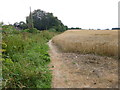
Weeke, footpath
An informal path along a field margin, avoiding traffic on the narrow Lanham Lane, parallel to the left.
Image: © Mike Faherty
Taken: 4 Aug 2013
0.03 miles
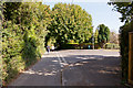
2
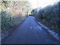
Dean Lane
Dean Lane nearing the crossroad with Lanham Lane and Salters Lane
Image: © Shaun Ferguson
Taken: 20 Dec 2009
0.04 miles
3

Old Boundary Marker by Dean Lane, Winchester parish
Parish Boundary Marker by the UC road, in parish of Winchester (Winchester District), Dean Lane, 100m West of junction with Lanham Lane, in undergrowth on South side of road.
Carved bench mark and rivet on top.
Surveyed
Milestone Society National ID: HA_WIN04pb
Image: © Milestone Society
Taken: Unknown
0.07 miles
4
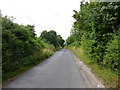
Weeke, Dean Lane
Country lane from Weeke to Dean, just outside the city boundary - a boundary post can be found, well hidden in the undergrowth nearby.
Image: © Mike Faherty
Taken: 4 Aug 2013
0.10 miles
5
Wyke Mark, Winchester
One of the many new housing developments on in-fill sites in Winchester, Wyke Mark is situated on Dean Lane, a woody lane leading north-westwards out of Winchester.
Image: © Peter Jordan
Taken: 7 Sep 2005
0.11 miles
6
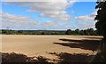
Farmland For Now
This is where Winchester stops at the moment. Off to the right is suburbs, in front countryside.
But no field this near a town is safe. What's the betting in two year's time this will be Hunters Rise or Badgers Drift or whatever.
Image: © Des Blenkinsopp
Taken: 21 Aug 2018
0.15 miles
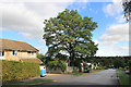
7
Top end of Teg Down Meads
A T-junction with the very narrow Lanham Lane.
Image: © Peter Facey
Taken: 22 Sep 2012
0.22 miles
8
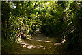
Lanham Lane
A bridleway and also vehicular access to a few properties on the right side of the lane.
Image: © Peter Facey
Taken: 22 Sep 2012
0.24 miles
9
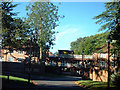
Grovelands Road, Winchester
About a quarter of SU4530 is suburbs like this. The rest is farmland.
Image: © Des Blenkinsopp
Taken: 21 Aug 2018
0.24 miles
10
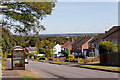
Grovelands Road
Looking across the city of Winchester from Grovelands Road which is fairly high up. The area in the distance would be Harestock and Weeke.
Image: © Peter Facey
Taken: 22 Sep 2012
0.24 miles