IMAGES TAKEN NEAR TO
Ruffield Close, WINCHESTER, SO22 5JL
Introduction
This page details the photographs taken nearby to Ruffield Close, SO22 5JL by members of the Geograph project.
The Geograph project started in 2005 with the aim of publishing, organising and preserving representative images for every square kilometre of Great Britain, Ireland and the Isle of Man.

There are currently over 7.5m images from over14,400 individuals and you can help contribute to the project by visiting https://www.geograph.org.uk
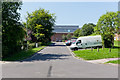
Image Map
Images are licensed for reuse under creativecommons.org/licenses/by-sa/2.0
Notes
- Clicking on the map will re-center to the selected point.
- The higher the marker number, the further away the image location is from the centre of the postcode.
Image Listing (25 Images Found)
Images are licensed for reuse under creativecommons.org/licenses/by-sa/2.0
Image
Details
Distance
1
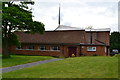
St Barnabas Church, Winchester
The church is set at the centre of a crescent and forms a prominent feature in the layout of this housing estate.
Image: © David Martin
Taken: 8 Jul 2014
0.10 miles
2
Burnett Close
Looking along the close, past the demolished former Chimneys pub.
Image: © Peter Facey
Taken: 25 Jul 2012
0.11 miles
3
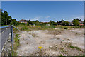
Site of former Chimneys pub, Weeke
This pub closed in 2004 and had been demolished. It is immediately north of the Waitrose supermarket.
Image: © Peter Facey
Taken: 25 Jul 2012
0.12 miles
4
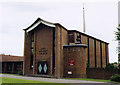
St Barnabas, Weeke, Winchester
Built in 1966.
Image: © Michael FORD
Taken: Unknown
0.14 miles
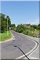
5
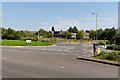
Burnett Close joins Stockbridge Road
Beyond is the site of the former Chimneys pub, which closed in 2004 and has been demolished.
Image: © Peter Facey
Taken: 25 Jul 2012
0.14 miles
6
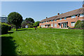
Housing off Fromond Road
With Waitrose supermarket glimpsed beyond trees at left.
Image: © Peter Facey
Taken: 25 Jul 2012
0.14 miles
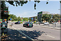
7
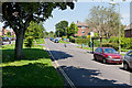
Fromond Road, Weeke
Looking along one lane of this dual-carriageway, which is a fairly quiet residential area and not a main thoroughfare. (The other lane can be seen to the left of the tree trunk.)
Image: © Peter Facey
Taken: 25 Jul 2012
0.15 miles
8
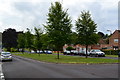
Fromond Road
A wide dual carriageway within this residential area.
Image: © David Martin
Taken: 8 Jul 2014
0.16 miles
9
Cul de sac running towards Waitrose Supermarket
Looking across one lane of Fromond Road.
Image: © Peter Facey
Taken: 25 Jul 2012
0.16 miles
10
Waitrose Shopping Complex at Weeke
Looking across Stockbridge Road. Built within the last three years.
Image: © Peter Facey
Taken: 25 Jul 2012
0.16 miles